File:11-Hetlingen-8260004.jpg
Original file (4,420 × 3,315 pixels, file size: 8.66 MB, MIME type: image/jpeg)
Captions
Summary[edit]
Description11-Hetlingen-8260004.jpg |
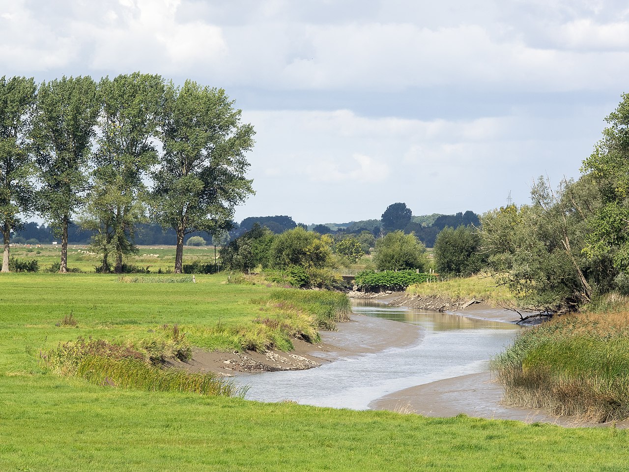
Deutsch: Der östliche Teil der Haseldorfer Binnenelbe heißt Hetlinger Binnenelbe. Östlich des Elbe-Sperrwerks, hier entstand das Bild, ändert sich der Name des Gewässers erneut, nunmehr ist es die Wedeler Au. Hier endet das Naturschutzgebiet.
English: The eastern part of the Haseldorfer Binnenelbe is named Hetlinger Binnenelbe. This shot was taken at the flood barrier where the name is changed once more into Wedeler Au. This barrier marks the eastern limit of the natural reserve. |
Date | |
Source | Own work |
Author | Oswald Pietzsch |
Camera location | 53° 34′ 40.11″ N, 9° 40′ 29.8″ E | View this and other nearby images on: OpenStreetMap | 53.577807; 9.674945 |
---|
Licensing[edit]
- You are free:
- to share – to copy, distribute and transmit the work
- to remix – to adapt the work
- Under the following conditions:
- attribution – You must give appropriate credit, provide a link to the license, and indicate if changes were made. You may do so in any reasonable manner, but not in any way that suggests the licensor endorses you or your use.
- share alike – If you remix, transform, or build upon the material, you must distribute your contributions under the same or compatible license as the original.
This image was uploaded as part of Wiki Loves Earth 2019.
aragonés | العربية | asturianu | azərbaycanca | беларуская (тарашкевіца) | български | বাংলা | brezhoneg | català | čeština | Cymraeg | Deutsch | Ελληνικά | English | español | eesti | euskara | فارسی | français | galego | עברית | hrvatski | հայերեն | Bahasa Indonesia | italiano | 日本語 | ქართული | 한국어 | latviešu | македонски | മലയാളം | मराठी | Bahasa Melayu | norsk bokmål | नेपाली | Nederlands | norsk | polski | português | português do Brasil | русский | sicilianu | shqip | slovenščina | српски / srpski | svenska | ไทย | Türkçe | українська | اردو | 中文 | 中文(台灣) | +/− |
File history
Click on a date/time to view the file as it appeared at that time.
Date/Time | Thumbnail | Dimensions | User | Comment | |
---|---|---|---|---|---|
current | 17:55, 31 May 2019 | 4,420 × 3,315 (8.66 MB) | Weezelbird (talk | contribs) | User created page with UploadWizard |
You cannot overwrite this file.
File usage on Commons
The following page uses this file:
File usage on other wikis
The following other wikis use this file:
- Usage on de.wikipedia.org
Metadata
This file contains additional information such as Exif metadata which may have been added by the digital camera, scanner, or software program used to create or digitize it. If the file has been modified from its original state, some details such as the timestamp may not fully reflect those of the original file. The timestamp is only as accurate as the clock in the camera, and it may be completely wrong.
Image title |
|
---|---|
Camera manufacturer | OLYMPUS IMAGING CORP. |
Camera model | E-M1 |
Author | Oswald Pietzsch |
Copyright holder |
|
Exposure time | 1/250 sec (0.004) |
F-number | f/10 |
ISO speed rating | 200 |
Date and time of data generation | 12:16, 26 August 2018 |
Lens focal length | 130 mm |
Latitude | 53° 34′ 40.1″ N |
Longitude | 9° 40′ 29.8″ E |
Altitude | 11 meters above sea level |
City shown | Wedel |
Horizontal resolution | 95 dpi |
Vertical resolution | 95 dpi |
Software used | Adobe Photoshop Lightroom 5.6 (Windows) |
File change date and time | 16:30, 30 May 2019 |
Exposure Program | Aperture priority |
Exif version | 2.3 |
Date and time of digitizing | 12:16, 26 August 2018 |
APEX shutter speed | 7.965784 |
APEX aperture | 6.643856 |
APEX exposure bias | 0 |
Maximum land aperture | 3 APEX (f/2.83) |
Metering mode | Spot |
Light source | Unknown |
Flash | Flash did not fire, auto mode |
Color space | sRGB |
Focal plane X resolution | 2,661.0214538574 |
Focal plane Y resolution | 2,661.0214538574 |
Focal plane resolution unit | 3 |
File source | Digital still camera |
Custom image processing | Normal process |
Exposure mode | Auto exposure |
White balance | Auto white balance |
Digital zoom ratio | 1 |
Focal length in 35 mm film | 260 mm |
Scene capture type | Standard |
Scene control | Low gain up |
Contrast | Normal |
Saturation | Normal |
Sharpness | Normal |
Receiver status | Measurement in progress |
GPS tag version | 0.0.3.2 |
Serial number of camera | BHP226653 |
Lens used | OLYMPUS M.40-150mm F2.8 |
Date metadata was last modified | 18:30, 30 May 2019 |
Rating (out of 5) | 3 |
Unique ID of original document | 8003F4F33A67B23ACCF3394DE0493758 |
Province or state shown | Schleswig-Holstein |
Country shown | Deutschland |
IIM version | 4 |
Structured data
Items portrayed in this file
depicts
53°34'40.105"N, 9°40'29.802"E
26 August 2018
0.004 second
10
130 millimetre
200
image/jpeg
189a9d286eb502760b048c7c31f93eb8593dabc7
9,080,940 byte
3,315 pixel
4,420 pixel
- Files with coordinates missing SDC location of creation (53° N, 9° E)
- CC-BY-SA-4.0
- Self-published work
- Images from Wiki Loves Earth 2019
- Images from Wiki Loves Earth 2019 in Germany
- Images from Wiki Loves Earth missing SDC depicts
- Images from Wiki Loves Earth missing SDC location of creation
- Images from Wiki Loves Earth 2019, DE-SH
- Uploaded via Campaign:wle-de-sh
- Schleswig-Holstein photographs taken on 2018-08-26
- Pages with maps