File:Aerial view the aviation field at the Sand Point Naval Air Station, Seattle, March 1928 (SEATTLE 2775).jpg

Original file (768 × 614 pixels, file size: 102 KB, MIME type: image/jpeg)
Captions
Captions

|
The categories of this image need checking. You can do so here.
|
.jpg&action=edit&withJS=MediaWiki:Catcheck.js)
|
|
|
This image was automatically transferred from the collections of the University of Washington. While certainly the majority of metadata in their database is correct, it is not necessarily written by individuals who are expert on the material they are describing. Such images often have incorrect dates, locations, or other information. If you can verify that this information is correct, or correct it if it isn't, please do so and remove this template. Also, if you are correcting information, please also let the library know so that they can update the metadata on their site. You can contact UW LIBRARIES MSCUA at photos |
Summary[edit]
.jpg&action=edit§ion=1)
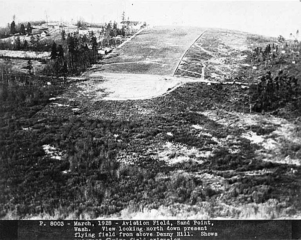
| English: Aerial view the aviation field at the Sand Point Naval Air Station, Seattle, March 1928
( |
||||||||||||||||||||||||
|---|---|---|---|---|---|---|---|---|---|---|---|---|---|---|---|---|---|---|---|---|---|---|---|---|
| Photographer |
Unknown author |
|||||||||||||||||||||||
| Title |
English: Aerial view the aviation field at the Sand Point Naval Air Station, Seattle, March 1928 |
|||||||||||||||||||||||
| Description |
English: Caption on image: P. 8003. March, 1928. Aviation field, Sand Point, Wash. View looking north down present flying field from above Denny Hill. PH Coll 765.1 The Sand Point Naval Air Station first became operational in June 1920. It was expanded in October 1926, when the Carkeek family sold some of their land to King County, and it was then deeded to the U.S. Navy for further development of the Naval Air Station. The new construction included the use of the Works Project Administration for filling Mud Lake and Pontiac Bay. The Air Station reached its peak during World War Two when numerous new buildings and landing strips were built and over 7,000 military and civilian personnel worked on the grounds. After World War Two, the use of the Air Station slowed, and it was deactivated on June 30, 1970. The land is now a park called Warren G. Magnusun Park.
|
|||||||||||||||||||||||
| Depicted place | Seattle | |||||||||||||||||||||||
| Date | Taken on 1 March 1928 | |||||||||||||||||||||||
| Dimensions | height: 8 in (20.3 cm); width: 10 in (25.4 cm) | |||||||||||||||||||||||
| Collection |
|
|||||||||||||||||||||||
| Current location | ||||||||||||||||||||||||
| Accession number | ||||||||||||||||||||||||
| Source |
English: Seattle Photographs |
|||||||||||||||||||||||
| Permission (Reusing this file) |
|
|||||||||||||||||||||||
| Order Number | SEA2794 | |||||||||||||||||||||||
File history
Click on a date/time to view the file as it appeared at that time.
| Date/Time | Thumbnail | Dimensions | User | Comment | |
|---|---|---|---|---|---|
| current | 05:43, 3 January 2024 | | 768 × 614 (102 KB) | BMacZeroBot (talk | contribs) | Automatic lossless crop (watermark) |
| 05:43, 3 January 2024 |  | 768 × 644 (106 KB) | BMacZeroBot (talk | contribs) | Batch upload (Commons:Batch uploading/University of Washington Digital Collections) |
You cannot overwrite this file.
File usage on Commons
The following page uses this file:
.jpg)
.jpg&oldid=850590765)