File:Firenze - mappa rete tranviaria.png
Jump to navigation
Jump to search
Size of this preview: 800 × 569 pixels. Other resolutions: 320 × 228 pixels | 640 × 455 pixels | 1,024 × 728 pixels | 1,280 × 910 pixels | 2,000 × 1,422 pixels.
Original file (2,000 × 1,422 pixels, file size: 3.64 MB, MIME type: image/png)
Captions
Captions
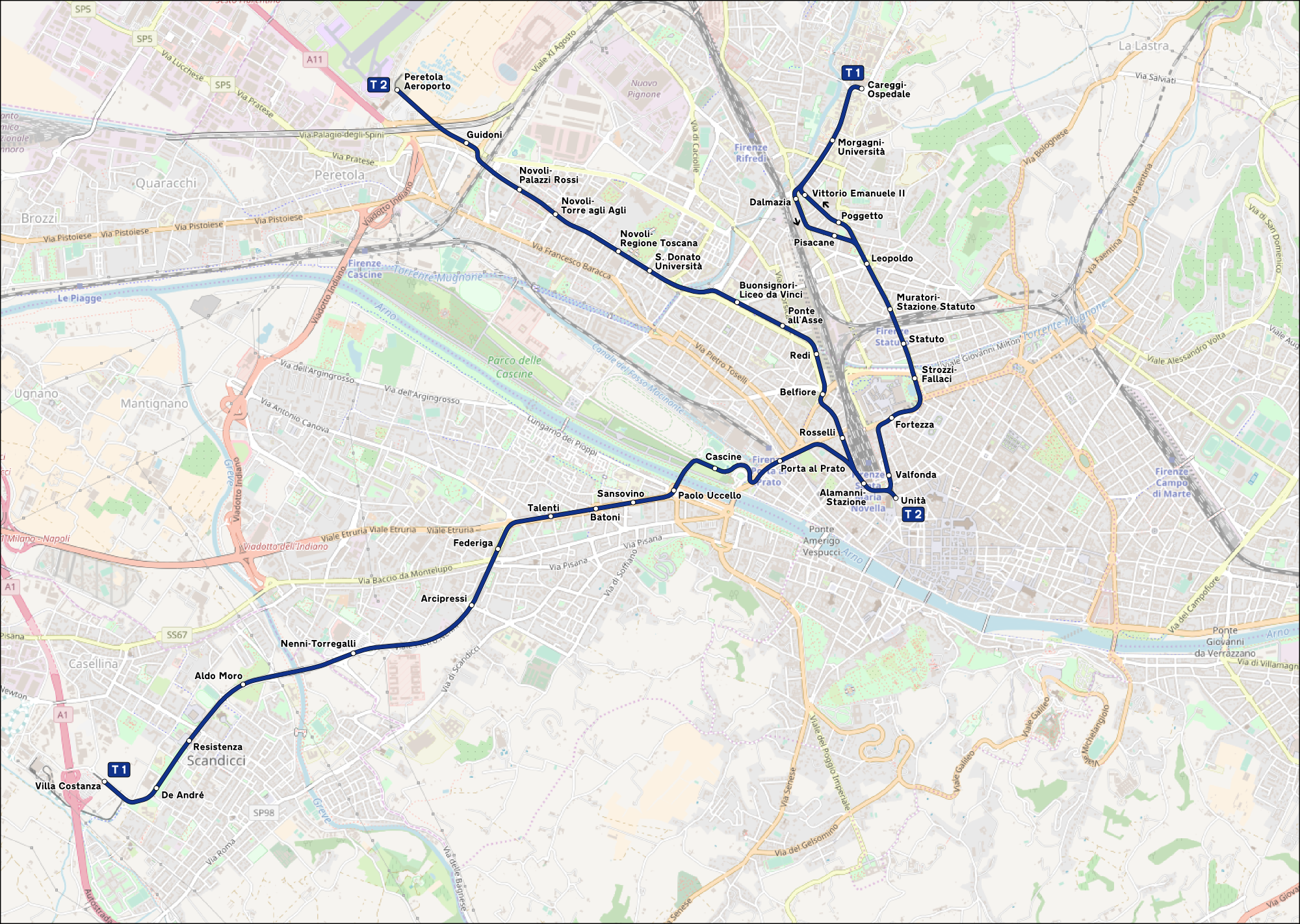
Route map of the tramway of Florence, Italy
Summary
[edit]| Description |
Italiano: Mappa della rete tranviaria di Firenze. |
|||
| Date | (see file history) | |||
| Source | openstreetmap.org | |||
| Creator |
OpenStreetMap contributors |
|||
| Permission (Reusing this file) |
OpenStreetMap data is available under the Open Database License (details). Map tiles are licensed under the Creative Commons Attribution-ShareAlike 2.0 license (CC-BY-SA 2.0).
This file is licensed under the Creative Commons Attribution-Share Alike 2.0 Generic license.
|
|||
| Georeferencing | If inappropriate please set warp_status = skip to hide. | |||
| Other versions |
|


File history
Click on a date/time to view the file as it appeared at that time.
| Date/Time | Thumbnail | Dimensions | User | Comment | |
|---|---|---|---|---|---|
| current | 20:54, 4 August 2023 | | 2,000 × 1,422 (3.64 MB) | Arbalete (talk | contribs) | Aggiorno (nuova fermata Redi) |
| 08:35, 9 November 2021 |  | 2,000 × 1,422 (3.64 MB) | Arbalete (talk | contribs) | Ripristino mappa rovinata da interventi maldestri | |
| 17:28, 9 January 2021 |  | 7,089 × 4,058 (17.91 MB) | Lorec10 (talk | contribs) | dimensioni fascicolo minori | |
| 15:52, 9 January 2021 |  | 19,495 × 11,160 (86.73 MB) | Lorec10 (talk | contribs) | migliorata la definizione. | |
| 11:54, 9 January 2021 |  | 1,490 × 853 (1.71 MB) | Lorec10 (talk | contribs) | aggiunte linee previste in futuro. | |
| 15:39, 4 March 2019 |  | 2,000 × 1,422 (3.64 MB) | Arbalete (talk | contribs) | Linea 2 attivata | |
| 10:48, 17 July 2018 |  | 2,000 × 1,422 (3.65 MB) | Arbalete (talk | contribs) | Linea T1 prolungata a Careggi il 16-07-2018 | |
| 11:34, 22 May 2018 |  | 2,000 × 1,422 (3.66 MB) | Arbalete (talk | contribs) | User created page with UploadWizard |
You cannot overwrite this file.
File usage on Commons
The following 23 pages use this file:
- User:Chumwa/OgreBot/Potential transport maps/2018 July 11-20
- User:Chumwa/OgreBot/Potential transport maps/2018 May 21-31
- User:Chumwa/OgreBot/Potential transport maps/2019 March 1-10
- User:Chumwa/OgreBot/Public transport information/2018 July 11-20
- User:Chumwa/OgreBot/Public transport information/2018 May 21-31
- User:Chumwa/OgreBot/Public transport information/2019 March 1-10
- User:Chumwa/OgreBot/Public transport information/2021 January 1-10
- User:Chumwa/OgreBot/Public transport information/2021 November 1-10
- User:Chumwa/OgreBot/Public transport information/2023 August 1-10
- User:Chumwa/OgreBot/Transport Maps/2018 July 11-20
- User:Chumwa/OgreBot/Transport Maps/2018 May 21-31
- User:Chumwa/OgreBot/Transport Maps/2019 March 1-10
- User:Chumwa/OgreBot/Transport Maps/2021 January 1-10
- User:Chumwa/OgreBot/Transport Maps/2021 November 1-10
- User:Chumwa/OgreBot/Transport Maps/2023 August 1-10
- User:Chumwa/OgreBot/Travel and communication maps/2018 July 11-20
- User:Chumwa/OgreBot/Travel and communication maps/2018 May 21-31
- User:Chumwa/OgreBot/Travel and communication maps/2019 March 1-10
- User:J budissin/Uploads/BiH/2018 July 11-20
- User:J budissin/Uploads/BiH/2018 May 21-31
- User:J budissin/Uploads/BiH/2019 March 1-10
- User:Minorax/SVG available/2023 August 1-6
- File:Firenze - mappa rete tranviaria.svg
File usage on other wikis
The following other wikis use this file:
- Usage on eo.wikipedia.org
- Usage on fa.wikipedia.org
- Usage on he.wikivoyage.org
- Usage on it.wikipedia.org
- Usage on mk.wikipedia.org