File:Map of Woolwich, 1740s.jpg
Jump to navigation
Jump to search

Size of this preview: 485 × 600 pixels. Other resolutions: 194 × 240 pixels | 388 × 480 pixels | 621 × 768 pixels | 828 × 1,024 pixels | 1,918 × 2,372 pixels.
Original file (1,918 × 2,372 pixels, file size: 4 MB, MIME type: image/jpeg)
Captions
Captions
Add a one-line explanation of what this file represents
Summary
[edit]| Description |
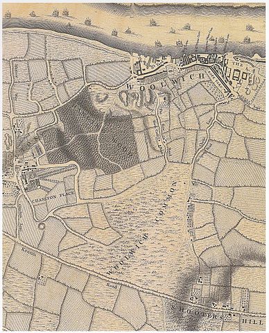
English: Woolwich in the 1740s. Detail of a map of London in the 18th c. Engraved by Richard Parr, surveyed and published by John Rocque, 1746. |
| Date | |
| Source | Saint, A., Guillery, P. (ed.), Woolwich – Survey of London, Volume 48, p. 11. Yale Books, London, 2012. ISBN 978 0 300 18722 9 |
| Author | John Rocque (c. 1709–1762) |
| Other versions |
.jpg)
Licensing
[edit]
|
This work is in the public domain in its country of origin and other countries and areas where the copyright term is the author's life plus 100 years or fewer. | |
| This file has been identified as being free of known restrictions under copyright law, including all related and neighboring rights. | |
File history
Click on a date/time to view the file as it appeared at that time.
| Date/Time | Thumbnail | Dimensions | User | Comment | |
|---|---|---|---|---|---|
| current | 12:12, 15 March 2017 | | 1,918 × 2,372 (4 MB) | Kleon3 (talk | contribs) | User created page with UploadWizard |
You cannot overwrite this file.
File usage on Commons
The following page uses this file: