File:Tennessee's Congressonal Districts (2023-).png
Jump to navigation
Jump to search

Size of this preview: 800 × 260 pixels. Other resolutions: 320 × 104 pixels | 640 × 208 pixels | 1,024 × 333 pixels | 1,280 × 416 pixels | 3,507 × 1,141 pixels.
Original file (3,507 × 1,141 pixels, file size: 905 KB, MIME type: image/png)
Captions
Captions
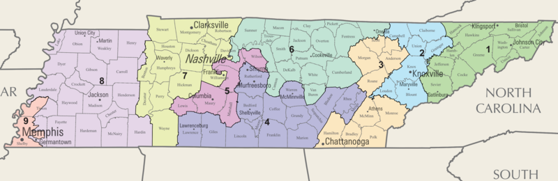
A map of the congressional districts of Tennessee, as well as counties and selected cities.
Summary
[edit].png&action=edit§ion=1)
| Description |
English: A map of the congressional districts of Tennessee, as well as county boundaries, county names, and selected cities. This map was made in the style of the older National Atlas maps, which does not exist anymore. |
| Date | |
| Source | Own work |
| Author | Twizzyu |
Licensing
[edit].png&action=edit§ion=2)
I, the copyright holder of this work, hereby publish it under the following license:
This file is licensed under the Creative Commons Attribution-Share Alike 4.0 International license.
- You are free:
- to share – to copy, distribute and transmit the work
- to remix – to adapt the work
- Under the following conditions:
- attribution – You must give appropriate credit, provide a link to the license, and indicate if changes were made. You may do so in any reasonable manner, but not in any way that suggests the licensor endorses you or your use.
- share alike – If you remix, transform, or build upon the material, you must distribute your contributions under the same or compatible license as the original.
File history
Click on a date/time to view the file as it appeared at that time.
| Date/Time | Thumbnail | Dimensions | User | Comment | |
|---|---|---|---|---|---|
| current | 06:21, 13 January 2023 | 3,507 × 1,141 (905 KB) | Twizzyu (talk | contribs) | Uploaded own work with UploadWizard |
You cannot overwrite this file.
File usage on Commons
The following page uses this file:
File usage on other wikis
The following other wikis use this file:
- Usage on en.wikipedia.org
- Usage on fr.wikipedia.org
- Usage on it.wikipedia.org
- Usage on ja.wikipedia.org
- Usage on simple.wikipedia.org
.png&oldid=728017349)