File:Texas Presidential Election Results 1860.png
Jump to navigation
Jump to search

Size of this preview: 600 × 600 pixels. Other resolutions: 240 × 240 pixels | 480 × 480 pixels | 768 × 768 pixels | 1,024 × 1,024 pixels | 2,048 × 2,048 pixels | 4,096 × 4,096 pixels.
Original file (4,096 × 4,096 pixels, file size: 1.28 MB, MIME type: image/png)
Captions
Captions
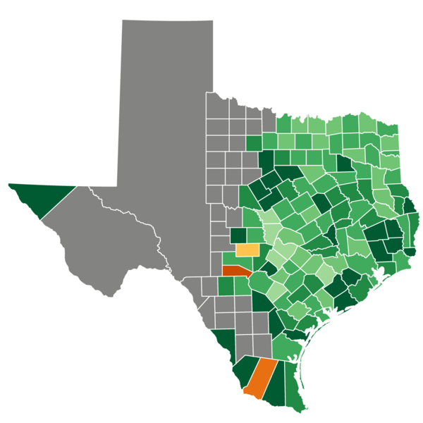
A map of the United States 1860 Presidential Election in Texas
Summary[edit]
| Description |
English: A map of the United States Presidential Election of 1860 in Texas by county.
Breckinridge 90-100%
Breckinridge 80-90%
Breckinridge 70-80%
Breckenridge 60-70%
Breckenridge 50-60%
Bell 50-60%
Bell 70-80%
Bell 80-90%
Unknown/No Vote |
| Date | |
| Source | Shapes and information derived from Tilden76, outlined and colored by Kosobay. |
| Author | Kosobay |
Licensing[edit]
I, the copyright holder of this work, hereby publish it under the following license:
This file is licensed under the Creative Commons Attribution-Share Alike 4.0 International license.
- You are free:
- to share – to copy, distribute and transmit the work
- to remix – to adapt the work
- Under the following conditions:
- attribution – You must give appropriate credit, provide a link to the license, and indicate if changes were made. You may do so in any reasonable manner, but not in any way that suggests the licensor endorses you or your use.
- share alike – If you remix, transform, or build upon the material, you must distribute your contributions under the same or compatible license as the original.
File history
Click on a date/time to view the file as it appeared at that time.
| Date/Time | Thumbnail | Dimensions | User | Comment | |
|---|---|---|---|---|---|
| current | 21:02, 20 December 2022 | | 4,096 × 4,096 (1.28 MB) | Kosobay (talk | contribs) | Cleaner borders and resolution |
| 21:14, 29 August 2022 |  | 1,280 × 1,218 (277 KB) | Kosobay (talk | contribs) | Uploaded own work with UploadWizard |
You cannot overwrite this file.
File usage on Commons
The following 2 pages use this file: