File:Western locks on Tammileru during floods 2020.jpg
Jump to navigation
Jump to search

Size of this preview: 800 × 450 pixels. Other resolutions: 320 × 180 pixels | 640 × 360 pixels | 1,024 × 576 pixels | 1,280 × 720 pixels | 2,560 × 1,440 pixels | 5,472 × 3,078 pixels.
Original file (5,472 × 3,078 pixels, file size: 13.09 MB, MIME type: image/jpeg)
Captions
Captions
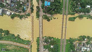
Tammileru floods 2020
Summary[edit]
| Description |
English: Flood water near Western lock in Eluru |
| Date | |
| Source | https://www.instagram.com/karun.photography/ |
| Author | Karun |
| Permission (Reusing this file) |
| Camera location | | View this and other nearby images on: OpenStreetMap |
|---|
Licensing[edit]
This file is licensed under the Creative Commons Attribution-Share Alike 4.0 International license.
- You are free:
- to share – to copy, distribute and transmit the work
- to remix – to adapt the work
- Under the following conditions:
- attribution – You must give appropriate credit, provide a link to the license, and indicate if changes were made. You may do so in any reasonable manner, but not in any way that suggests the licensor endorses you or your use.
- share alike – If you remix, transform, or build upon the material, you must distribute your contributions under the same or compatible license as the original.
File history
Click on a date/time to view the file as it appeared at that time.
| Date/Time | Thumbnail | Dimensions | User | Comment | |
|---|---|---|---|---|---|
| current | 16:00, 15 October 2020 | | 5,472 × 3,078 (13.09 MB) | IM3847 (talk | contribs) | Uploaded a work by Karun from https://www.instagram.com/karun.photography/ {{OTRS Pending}} with UploadWizard |
You cannot overwrite this file.
File usage on Commons
The following 2 pages use this file:
File usage on other wikis
The following other wikis use this file:
- Usage on ceb.wikipedia.org
- Usage on en.wikipedia.org
- Usage on hi.wikipedia.org
- Usage on www.wikidata.org