File talk:Somali Civil War (2009-present).svg
Khatumo state control is wrong
[edit].svg&action=edit§ion=1)
This map shows Khatumo as in control of a huge swath of territory between Somaliland and puntland. This is not reflected in the sources available. Las Anod is firmly in the control of Somaliland forces. Per this source [[1]] Buhoodle has fallen under the control of a local warlord who seized it from Khatumo forces.XavierGreen (talk) 18:55, 3 May 2016 (UTC)
.svg#c-XavierGreen-2016-05-03T18:55:00.000Z-Khatumo_state_control_is_wrong)
Legend
[edit].svg&action=edit§ion=2)
what is the meaning of blue (around Beledweyne and Merca)? --79.194.228.109 11:52, 27 May 2016 (UTC)
.svg#c-79.194.228.109-2016-05-27T11:52:00.000Z-Legend)
update
[edit].svg&action=edit§ion=3)
This needs an update. — Preceding unsigned comment was added by 108.4.159.12 (talk) 01:03, 27 October 2016 (UTC)
.svg#c-108.4.159.12-2016-10-27T01:03:00.000Z-update)
update 2018
[edit].svg&action=edit§ion=4)
If there are active members, can someone update the map--Murza-Zade (talk) 08:08, 20 September 2018 (UTC)
.svg#c-Murza-Zade-2018-09-20T08:08:00.000Z-update_2018)
The Puntland state itself is not marked...
[edit].svg&action=edit§ion=5)
If there is a separatly colored territory described as "Disputed territory between Somaliland and Puntland" then it is really peculiar that the Puntland state is not. 5.174.153.75 08:48, 7 January 2023 (UTC)
.svg#c-5.174.153.75-20230107084800-The_Puntland_state_itself_is_not_marked...)
Some changes
[edit].svg&action=edit§ion=6)
Somali forces recaptured Haradhere (see the article about Somali civil war (2009- )). See here:[1] Пан Хаунд (talk) 14:32, 2 March 2023 (UTC)
.svg#c-Пан_Хаунд-20230302143200-Some_changes)
Changes
[edit].svg&action=edit§ion=7)
The areas/towns of Rab Dhuure, Burgabo, and Qanadala have been recaptured from Al-Shabaab/ISIS, and the town/area of Fafahdun has been captured by Al-Shabaab. RowanJ LP2 (talk) 21:04, 29 October 2023 (UTC)
.svg#c-RowanJ_LP2-20231029210400-Changes)
Most recent map by REACH and Unosat
[edit].svg&action=edit§ion=8)
https://twitter.com/EmreAltinbas89/status/1736864862611845259 Billboardbillal (talk) 07:51, 26 December 2023 (UTC)
.svg#c-Billboardbillal-20231226075100-Most_recent_map_by_REACH_and_Unosat)
Updating northern region.
[edit].svg&action=edit§ion=9)
The borders between Somaliland and Puntland have remained unchanged since 2020.
I've revised the map due to numerous developments in the last four years within the disputed territory, notably Puntland holding voter registration in all of Eastern Sanaag in 2023 and the current frontlines between Somaliland and SSC-Khaatumo have moved away from Las Anod to Oog/Guumays.
I've additionally removed the Khatumo and disputed Puntland shading, as both entities are under the Somali government. Sifeeye (talk) 23:03, 12 January 2024 (UTC)
.svg#c-Sifeeye-20240112230300-Updating_northern_region.)
- @Hawkers994 Why revert the changes I've made? I've linked my sources above, what are your sources that Somaliland control anything east of Oog or Erigavo? Sifeeye (talk) 17:26, 18 January 2024 (UTC)
- Undependable source, no were in the article does it state sanaag or places are under militia control. The last reliable source is correctly used which correlates to that particular file. Hawkers994 (talk) 20:26, 18 January 2024 (UTC)
- If HiiraanOnline is undependable for you, then there are also articles and reports from reputable sources such as the International Crisis Group that have reported on recent frontline changes in Sool.
- On the Horizon: October 2023-March 2024 | Crisis Group
The new frontlines between Dhulbahante clan militias and government forces stablised in September after the Dhulbahante captured several army positions near Las Anod, the capital of Sool region, effectively driving Somaliland forces out of Dhulbahante territory.
A spark from either side could set off new fighting on the frontline between Oog and Guumays towns in Sool.
- I've also linked the results of Puntland's voter registration from the Transitional Puntland Electoral Commission's official Facebook page. The post includes a full breakdown of all polling stations' locations in Sanaag. You can see the villages and towns in Erigabo district that took part in the voter registration but are currently wrongly listed as controlled by Somaliland forces.
- This map shows how the situation in the Somali Civil War keeps changing, it's absurd that you're clinging to a four year old version and refusing to consider any new sources. Sifeeye (talk) 22:23, 18 January 2024 (UTC)
- The whole map is incorrect. There is no gabiley under Berbera location, which is why it’s an incorrect revert Hawkers994 (talk) 08:54, 28 February 2024 (UTC)
- @Hawkers994: Can you explain this a little more. Gabiley seems to be in the same location and under the control of Somaliland in the other versions. We cannot keep using a 2020 version of this conflict, what changes would you be OK with to bring an accurate map of this conflict up to date with 2024? Would you agree to Freetrashbox's proposal below? Abzeronow (talk) 17:52, 28 February 2024 (UTC)
- I think they're talking about how Gabiley is in the wrong location and how that invalidates the new map. It also invalidates the old map so I'm not sure why this line is being used. But they are correct about how there is no town called Gabiley (or at least no notable one) southeast of Berbera like the new and old map show. You can see by checking other maps but the town of Gabiley is in reality located a tad northwest of Hargeisa. Like it is here https://en.wikipedia.org/wiki/Template:Somali_Civil_War_detailed_map. Overall I think Freetrashbox's proposal would be agreeable, though Gabiley should be relocated so the conversation can be focused on the real issue at hand, that being source dependability.
- Ope. I think I found the origin of the error. As you can see here https://maps.lib.utexas.edu/maps/tpc/txu-pclmaps-oclc-22834566_k-6d.jpg (Center left of 6-1) there is a spring called Karin Gabiile, or just Gabileh here https://maps.lib.utexas.edu/maps/onc/txu-pclmaps-oclc-8322829_k_6.jpg (Bottom center of 7-1) Both are topographic maps from Perry-Castañeda Library Map Collection https://maps.lib.utexas.edu/maps/topo/ AVeryBigHat (talk) 18:30, 30 April 2024 (UTC)
- Ah, OK. I would agree that the location of Gabiley should be fixed. Abzeronow (talk) 18:36, 30 April 2024 (UTC)
- @Hawkers994: Can you explain this a little more. Gabiley seems to be in the same location and under the control of Somaliland in the other versions. We cannot keep using a 2020 version of this conflict, what changes would you be OK with to bring an accurate map of this conflict up to date with 2024? Would you agree to Freetrashbox's proposal below? Abzeronow (talk) 17:52, 28 February 2024 (UTC)
- The whole map is incorrect. There is no gabiley under Berbera location, which is why it’s an incorrect revert Hawkers994 (talk) 08:54, 28 February 2024 (UTC)
- Undependable source, no were in the article does it state sanaag or places are under militia control. The last reliable source is correctly used which correlates to that particular file. Hawkers994 (talk) 20:26, 18 January 2024 (UTC)
.svg#c-Sifeeye-20240118172600-Sifeeye-20240112230300)
.svg#c-Hawkers994-20240118202600-Sifeeye-20240118172600)
.svg#c-Sifeeye-20240118222300-Hawkers994-20240118202600)
.svg#c-Hawkers994-20240228085400-Sifeeye-20240118222300)
.svg#c-Abzeronow-20240228175200-Hawkers994-20240228085400)
.svg#c-AVeryBigHat-20240430183000-Abzeronow-20240228175200)
.svg#c-Abzeronow-20240430183600-AVeryBigHat-20240430183000)
Both are inappropriate. The map of Hawkers994 shows Las Anod, which is not controlled by Somaliland, as being under Somaliland control. However, that is clearly wrong, and there are a number of sources that indicate that Somaliland has withdrawn from Las Anod. On the other hand, Sifeeye's map lacks evidence. Cities such as Badhan, Buuhoodle, and Las Anod on this map are not under Somaliland control, but the towns in between are unknown, with a few exceptions. My suggestion is that the area that the two are disputing should be entered as a "Disputed Area" as indicated by the BBC, and only towns that are known to belong should be entered separately. Freetrashbox (talk) 12:50, 29 January 2024 (UTC)
.svg#c-Freetrashbox-20240129125000-Updating_northern_region.)
- This sounds like a reasonable compromise. Abzeronow (talk) 17:30, 29 January 2024 (UTC)
.svg#c-Abzeronow-20240129173000-Freetrashbox-20240129125000)
- UNOSAT is the United Nations Satellite Centre, and is a reliable source and is recent (December 2023). This map by them suggests the map of Sifeeye is for the most part correct and up-to-date. Billboardbillal (talk) 21:49, 29 January 2024 (UTC)
- There is no evidence that UNOSAT created the linked map. Freetrashbox (talk) 11:11, 30 January 2024 (UTC)
.svg#c-Billboardbillal-20240129214900-Freetrashbox-20240129125000)
.svg#c-Freetrashbox-20240130111100-Billboardbillal-20240129214900)
Map conflicts
[edit].svg&action=edit§ion=10)
@Sifeeye, Hawkers994, AVeryBigHat, Abzeronow, Freetrashbox, Billboardbillal, and Ecrusized:
Ok so I've reverted back to the map which shows Khatumo State with that large swath of land as per a map from the Crsis Group which I believe is pretty reliable. More specifically it states in another issue that the "Front line shifted away from Sool region’s capital Las Anod. Following Dhulbahante militiamen’s major victory with Aug capture of Goojacade army base near Las Anod, new front line emerged between Oog and Guumays villages in western Sool. New division corresponds roughly to boundaries between Isaaq and Dhulbahante clans, with Isaaq being dominant grouping in Somaliland." According to its newest issue the frontline has remianed the same with a lull in fighting.
Hawkers994 says that map is wrong tho but he has not provided sources saying that his is right and I couldn't find it in the changes. I don't think it's reaonable to use an old map just because a place is in a wrong location.
The map apparently from the UNOSAT links back to reddit, which isn't a reliable source.
Concerning Al-Shabaab control, I know nothing about lol but that's where the most difference seems to be. The current map for Al-Shabaab control I believe comes from Political Geography Now which dates back to 2021 (3 year old) and I have no idea the reliablity of. I think that map of control also incorperates a newer 2023 issue (1 year old) for the Harhardhere area.
Again I don't know the source for the other map of its control because there's no source listed for it in the section above.
There's also a 2022 (2 year old) map from the African Center for Strategic Studies which gives Al-Sabaab a lot of control.
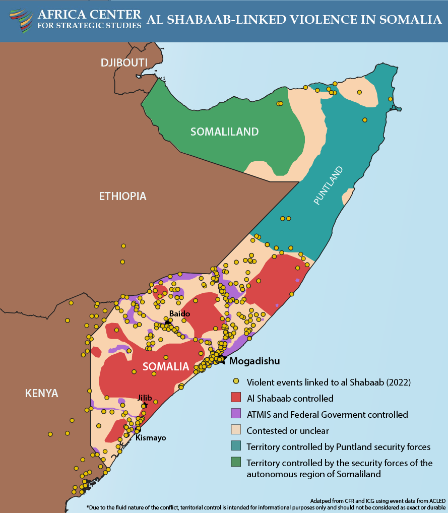
Lastly, there's map pushed by Ecrusized on both of the Somali Civil War main pages which gives Al-Sabaab even more control. This maps cites a tw itter post which is something I would not consider reliable. It also does not include Khatumo territory such as Las Anod.
Oh and there's also the Module:Somali Civil War detailed map which is all over the place.
Wowzers122 (talk) 15:49, 31 May 2024 (UTC)
.svg#c-Wowzers122-20240531154900-Map_conflicts)
- @Wowzers122: I'm not "pushing" anything and I have no personal interest in these maps. The current map, including the one you've added does not have a single reference. For that reason I replaced it with what I could find. The references you've listed above are dating back to 2021 and 2023, prior to the File:Somali Al-Shabaab Offensive (2022-23).svg. (The sourcing of this file is in the talk page).
- Apologies if my previous message was unclear. I didn't mean "pushing" in a negative way, nor did I imply any personal interest in the maps on your part. I mentioned you because you created a map that conflicts with another one, and that map was added to the main pages by you. My concern is that there should be consensus on the differences instead of having multiple conflicting maps. Another issue is the lack of sources. I started the discussion to find sources for an up-to-date map since there was some conversation happening here awhile back. I reverted to the previous map because it showed Khatumo State, which controls that territory, unlike the other map. Like I said I know nothing of the southern conflict and just stated references I found in the file changes. I stated the years because they were of concern to me. I couldn't find sources in the file changes for the other map version, as I previously mentioned. Wowzers122 (talk) 21:30, 2 June 2024 (UTC)
- @Wowzers122: ... You are not addressing the primary issue here which are citations. I came across that Twitter post a few days ago and decided the create a new file because the old one was not citing ANYTHING. Which is a common issue in most Wikipedia maps. "modules" citing other Wikipedia pages are not citations. I uploaded a new file, because I know many users tend to edit war in these war map files. I didn't modify anything except what was precisely shown in the twitter post which I cited. It is currently the only map showing the Somali Civil War that actually cites a source. It is also up to date. Please adress this first. The account cited belongs to this news website: https://actafabula.net/ Ecrusized (talk) 21:56, 2 June 2024 (UTC)
- Yes, the lack of sources is also a concern of mine, but I am not suggesting using modules or Wikipedia as a source. I apologize for not noticing that the account was linked to an actual news site and that it is their official account. I now believe that your map the best version to use for the main pages. However, it lacks a citation for the conflict in the north, which should at least show the disputed territory between Khatumo State and Somaliland. You criticize this map for having no sources, but yours cites this map as a source for the north. I've provided a source from the Crisis Group for the conflict there, and another person below cited a BBC article showing the disputed area. Wowzers122 (talk) 22:26, 2 June 2024 (UTC)
- I could adjust Somaliland as its seen in this file or here File:Somaliland (orthographic projection).svg. Otherwise you can modify the file I've uploaded and post it here and I can save it, or you can request overwrite access on my file, however, I wouldn't suggest the latter tends to result in edit warring between editors. Ecrusized (talk) 23:13, 2 June 2024 (UTC)
- Yes, the lack of sources is also a concern of mine, but I am not suggesting using modules or Wikipedia as a source. I apologize for not noticing that the account was linked to an actual news site and that it is their official account. I now believe that your map the best version to use for the main pages. However, it lacks a citation for the conflict in the north, which should at least show the disputed territory between Khatumo State and Somaliland. You criticize this map for having no sources, but yours cites this map as a source for the north. I've provided a source from the Crisis Group for the conflict there, and another person below cited a BBC article showing the disputed area. Wowzers122 (talk) 22:26, 2 June 2024 (UTC)
- @Wowzers122: ... You are not addressing the primary issue here which are citations. I came across that Twitter post a few days ago and decided the create a new file because the old one was not citing ANYTHING. Which is a common issue in most Wikipedia maps. "modules" citing other Wikipedia pages are not citations. I uploaded a new file, because I know many users tend to edit war in these war map files. I didn't modify anything except what was precisely shown in the twitter post which I cited. It is currently the only map showing the Somali Civil War that actually cites a source. It is also up to date. Please adress this first. The account cited belongs to this news website: https://actafabula.net/ Ecrusized (talk) 21:56, 2 June 2024 (UTC)
- Apologies if my previous message was unclear. I didn't mean "pushing" in a negative way, nor did I imply any personal interest in the maps on your part. I mentioned you because you created a map that conflicts with another one, and that map was added to the main pages by you. My concern is that there should be consensus on the differences instead of having multiple conflicting maps. Another issue is the lack of sources. I started the discussion to find sources for an up-to-date map since there was some conversation happening here awhile back. I reverted to the previous map because it showed Khatumo State, which controls that territory, unlike the other map. Like I said I know nothing of the southern conflict and just stated references I found in the file changes. I stated the years because they were of concern to me. I couldn't find sources in the file changes for the other map version, as I previously mentioned. Wowzers122 (talk) 21:30, 2 June 2024 (UTC)
.svg)
.svg#c-Wowzers122-20240602213000-Wowzers122-20240531154900)
.svg#c-Ecrusized-20240602215600-Wowzers122-20240602213000)
.svg#c-Wowzers122-20240602222600-Ecrusized-20240602215600)
.svg)
.svg#c-Ecrusized-20240602231300-Wowzers122-20240602222600)

.
- @Wowzers122: I've modified the Somaliland border and restored the file on English Wikipedia page for Somali Civil War. Ecrusized (talk) 11:40, 7 June 2024 (UTC) thumb|right.
- In this wall of text, you are discrediting other sources you've found, and replacing it with Wikipedia module, that is again fully unreferenced. w:WP:NOTSOURCE. Ecrusized (talk) 19:10, 31 May 2024 (UTC)
- I am not replacing it with the Wikipedia module; in fact, I discredited it because, as I mentioned, it's all over the place. Additionally, I discredited yours because Twitter is not a reliable source and should not be used, which is what your map relies on. The only source I find that I believe is reliable is from the Crisis Group, but that only covers the north. I would like to thank you, however, for mentioning the sources in the talk of File:Somali Al-Shabaab Offensive (2022-23).svg as it seems to also be reliable. Wowzers122 (talk) 21:30, 2 June 2024 (UTC)
- In the discussion section above, it appears Gabiley's location is erroneous. That should be fixed. Abzeronow (talk) 19:18, 31 May 2024 (UTC)
- @Wowzers122: The Crsis Group's map does not show the Khatumo State's territory, it only shows that this is a disputed area, as does the BBC. In other words, the Crsis Group's map is also evidence that neither the designation of this area as Somalia (Khatumo State) nor Somaliland is neutral. Freetrashbox (talk) 05:53, 2 June 2024 (UTC)
- Are you sure? It does not state that it's the disputed territory, and as shown by the BBC map, the disputed area is more to the west. The Crisis Group page discusses the shift in the frontline which is why I believe it's showing the frontline. Plus, it also matches the description of the frontline from the same page which is "between Oog and Guumays villages in western Sool." Wowzers122 (talk) 21:59, 2 June 2024 (UTC)
- I agree with Freetrashbox that Khatumo State should be put as "disputed territory" separate from Somalia and Somaliland. Abzeronow (talk) 20:50, 2 June 2024 (UTC)
- I think this is a reasonable compromise as long as it also shows the places that we know for sure are in the hands of each. Wowzers122 (talk) 22:02, 2 June 2024 (UTC)
- Pinging @Wowzers122: once again. You do not appear to be responding to multiple users whom you have pinged including myself. Please provide explicitly what source you are using to update the file. As I've said above, Wikipedia is not a source. Neither is mixing multiple sources for obvious synthesis issues. Ecrusized (talk) 20:47, 2 June 2024 (UTC)
- Calm down I was uploading a mass amount of maps I had finished and then was going to respond to this. Wowzers122 (talk) 21:02, 2 June 2024 (UTC)
.svg#c-Ecrusized-20240607114000-Map_conflicts)
.svg#c-Ecrusized-20240531191000-Ecrusized-20240607114000)
.svg#c-Wowzers122-20240602213000-Ecrusized-20240531191000)
.svg#c-Abzeronow-20240531191800-Ecrusized-20240531191000)
.svg#c-Freetrashbox-20240602055300-Ecrusized-20240607114000)
.svg#c-Wowzers122-20240602215900-Freetrashbox-20240602055300)
.svg#c-Abzeronow-20240602205000-Freetrashbox-20240602055300)
.svg#c-Wowzers122-20240602220200-Abzeronow-20240602205000)
.svg#c-Ecrusized-20240602204700-Ecrusized-20240607114000)
.svg#c-Wowzers122-20240602210200-Ecrusized-20240602204700)
- ↑ Somali Forces Capture Two Towns from Militants. voanews. Voice of America. Retrieved on 19 January 2023.
.svg&oldid=881901775)