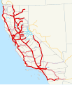
File:1920 California state highways.svg
From Wikimedia Commons, the free media repository
Jump to navigation
Jump to search

Size of this PNG preview of this SVG file: 514 × 600 pixels. Other resolutions: 206 × 240 pixels | 411 × 480 pixels | 658 × 768 pixels | 878 × 1,024 pixels | 1,755 × 2,048 pixels | 576 × 672 pixels.
Original file (SVG file, nominally 576 × 672 pixels, file size: 1.35 MB)
File information
Structured data
Captions
Captions
Add a one-line explanation of what this file represents
Summary[edit]
| Description1920 California state highways.svg | This is a map of California's state highway system (constructed and proposed routes) as it existed in 1920. Routes are color-coded by how they were added: red for the bond issues (1910, 1916, 1919), with the darkest red in 1910, and black for roads added by legislative acts (1895-1919). If a road was legislated but also in a bond issue, it is shown as red. Email me if you would like a copy of the GIS data I created for the highways. |
| Date | 3 December 2007 (original upload date) |
| Source | No machine-readable source provided. Own work assumed (based on copyright claims). |
| Author | No machine-readable author provided. NE2 assumed (based on copyright claims). |
Licensing[edit]
| Public domainPublic domainfalsefalse |
| I, the copyright holder of this work, release this work into the public domain. This applies worldwide. In some countries this may not be legally possible; if so: I grant anyone the right to use this work for any purpose, without any conditions, unless such conditions are required by law. |
File history
Click on a date/time to view the file as it appeared at that time.
| Date/Time | Thumbnail | Dimensions | User | Comment | |
|---|---|---|---|---|---|
| current | 04:26, 20 December 2007 |  | 576 × 672 (1.35 MB) | NE2 (talk | contribs) | Changed some positioning and blue to black. |
| 18:09, 3 December 2007 |  | 576 × 672 (1.25 MB) | NE2 (talk | contribs) | Added more in Nevada. | |
| 18:08, 3 December 2007 |  | 576 × 672 (1.25 MB) | NE2 (talk | contribs) | Added more in Nevada. | |
| 16:02, 3 December 2007 |  | 576 × 672 (1.24 MB) | NE2 (talk | contribs) | == Summary == This is a map of California's state highway system (constructed and proposed routes) as it existed in 1920. Routes are color-coded by how they were added: red for the bond issues (1910, 1916, 1919), with the darkest red in 1910, and blue for |
You cannot overwrite this file.
File usage on Commons
There are no pages that use this file.