Category:Bloody Foreland
Jump to navigation
Jump to search
cape in County Donegal, Ireland | |||||
| Upload media | |||||
| Instance of | |||||
|---|---|---|---|---|---|
| Location | County Donegal, Ulster, Ireland | ||||
 | |||||
Media in category "Bloody Foreland"
The following 11 files are in this category, out of 11 total.
-
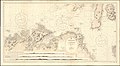 Admiralty Chart No 46 Ailsa Craig to Bloody Foreland, Published 1861.jpg 20,202 × 11,078; 58.98 MB
-
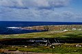
 Bloody Foreland - geograph.org.uk - 552789.jpg 640 × 425; 109 KB
-
 Bloody Foreland - geograph.org.uk - 87442.jpg 640 × 480; 75 KB
-
 Bloody foreland.jpg 604 × 452; 61 KB
-

-

-

-
 Brinlack - Houses near Bloody Foreland - geograph.org.uk - 1180529.jpg 639 × 426; 234 KB
-
 Gweedore area - Bloody Foreland - geograph.org.uk - 1337837.jpg 640 × 427; 71 KB
-
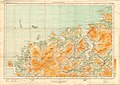 Ordnance Survey Ireland Half-Inch Sheet 1 Londonderry, Published 1952.jpg 12,170 × 8,629; 9.76 MB
-
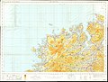 Ordnance Survey Ireland Half-Inch Sheet 1 The North West, Published 1970.jpg 16,044 × 12,161; 59.99 MB


