Category:Election maps of Northern Ireland
Jump to navigation
Jump to search
Wikimedia category | |||||
| Upload media | |||||
| Instance of | |||||
|---|---|---|---|---|---|
| Category combines topics | |||||
| |||||
Subcategories
This category has the following 6 subcategories, out of 6 total.
Media in category "Election maps of Northern Ireland"
The following 200 files are in this category, out of 205 total.
(previous page) (next page)-
 1921 Northern Ireland General Election Results Map.png 1,868 × 1,314; 325 KB
-
 1925 Northern Ireland General Election Results Map.png 1,968 × 1,314; 348 KB
-
 1929UlsterParliament.svg 1,000 × 750; 490 KB
-
 1933 Northern Ireland Assembly Election Results Map.svg 2,400 × 1,500; 544 KB
-
 1938 Northern Ireland Assembly Election Results Map.svg 2,400 × 1,500; 572 KB
-
 1945 Northern Ireland Assembly Election Results Map.svg 2,400 × 1,500; 565 KB
-
 1949 Northern Ireland Assembly Election Results Map.svg 2,400 × 1,500; 542 KB
-
 1982 Northern Ireland Assembly election.svg 512 × 341; 97 KB
-
 1996 Northern Ireland Forum election, Seats per Constituencies.svg 512 × 361; 911 KB
-
 1996 Northern Ireland Forum for Political Dialogue election.svg 512 × 341; 176 KB
-
 1998 Northern Ireland Assembly election, Seats per Constituencies.svg 512 × 483; 1.16 MB
-
 1998 Northern Ireland Assembly election.svg 512 × 341; 181 KB
-
 2003 Northern Ireland Assembly election, Seats per Constituencies.svg 512 × 368; 892 KB
-
 2003 Northern Ireland Assembly election.svg 512 × 341; 180 KB
-
 2007 Northern Ireland Assembly election, Seats per Constituencies.svg 512 × 368; 892 KB
-
 2007 Northern Ireland Assembly election.svg 512 × 341; 179 KB
-
 2011 Northern Ireland Assembly election, Seats per Constituencies.svg 512 × 368; 843 KB
-
 2011 Northern Ireland Assembly election.svg 512 × 341; 180 KB
-
 2016 Northern Ireland Assembly election, Seats per Constituencies.svg 512 × 368; 844 KB
-
 2016 Northern Ireland Assembly election.svg 512 × 341; 180 KB
-
 2017 Northern Ireland Assembly election, Seats per Constituencies.svg 512 × 368; 842 KB
-
 2017 Northern Ireland Assembly election.svg 512 × 341; 178 KB
-
 2019 United Kingdom general election in Northern Ireland.svg 512 × 597; 253 KB
-
 2022 December Northern Ireland Assembly Election Results Map.svg 2,400 × 1,500; 381 KB
-
 2022 Northern Ireland Assembly election, Seats per Constituencies.svg 512 × 368; 841 KB
-
 2022 Northern Ireland Assembly election.svg 512 × 341; 179 KB
-
 2022 Northern Ireland Election Map.svg 2,400 × 1,500; 401 KB
-
 2023 Northern Ireland local elections.svg 818 × 734; 15.7 MB
-
 Antrim - 2001.png 620 × 407; 31 KB
-
 Antrim - 2005.png 620 × 407; 30 KB
-
 Antrim - 2011.png 620 × 407; 31 KB
-
 Antrim and Newtownabbey - 2019 V2.png 1,408 × 848; 148 KB
-
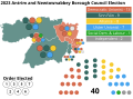 Antrim and Newtownabbey Borough Council Election 2023.svg 1,156 × 851; 544 KB
-
 Antrim and Newtownabbey.png 1,302 × 797; 128 KB
-
 Antrim and Newtownabbey2023.png 1,408 × 848; 114 KB
-
 Antrim and Newtownabby - 2014 v2.png 1,408 × 848; 148 KB
-
 Antrim and Newtownabby - 2014.png 1,302 × 797; 130 KB
-
 Antrim Bannside Constituency 1929-1969.svg 2,000 × 1,500; 455 KB
-
 Antrim Borough Constituency 1929-1969.svg 2,000 × 1,500; 455 KB
-
 Antrim Carrick Constituency 1929-1969.svg 2,000 × 1,500; 455 KB
-
 Antrim Larne Constituency 1929-1969.svg 2,000 × 1,500; 455 KB
-
 Antrim Mid Constituency 1929-1969.svg 2,000 × 1,500; 455 KB
-
 Antrim North Constituency 1929-1969.svg 2,000 × 1,500; 455 KB
-
 Antrim South Constituency 1929-1969.svg 2,000 × 1,500; 455 KB
-
 Ards - 2001.png 396 × 527; 24 KB
-
 Ards and North Down Borough Council Election 2023.svg 1,156 × 851; 786 KB
-
 Ards and Noth Down - 2014 v2.png 733 × 934; 100 KB
-
 Ards and Noth Down - 2014.png 800 × 940; 93 KB
-
 Ards and Noth Down - 2019.png 733 × 934; 100 KB
-
 Ards and Noth Down.png 800 × 940; 93 KB
-
 Ards2023.png 733 × 934; 101 KB
-
 Armagh City, Banbridge and Craigavon - 2014 V2.png 1,255 × 772; 136 KB
-
 Armagh City, Banbridge and Craigavon - 2014.png 1,060 × 777; 126 KB
-
 Armagh City, Banbridge and Craigavon - 2019.png 1,255 × 772; 134 KB
-
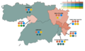
 Armagh City, Banbridge and Craigavon - 2023.png 1,255 × 772; 138 KB
-
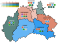
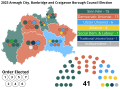 Armagh City, Banbridge and Craigavon Borough Council Election 2023.svg 1,156 × 851; 949 KB
-
 Armagh City, Banbridge and Craigavon Updated.png 1,060 × 777; 125 KB
-
 Armagh City, Banbridge and Craigavon.png 1,060 × 777; 116 KB
-
 Belfast Ballynafeigh 1929-1969.svg 1,500 × 1,500; 87 KB
-
 Belfast Bloomfield 1929-1969.svg 1,500 × 1,500; 88 KB
-
 Belfast Central 1929-1969.svg 1,500 × 1,500; 88 KB
-
 Belfast City Council seat map (live).png 2,160 × 2,160; 801 KB
-
 Belfast Clifton 1929-1969.svg 1,500 × 1,500; 88 KB
-
 Belfast Cormac 1929-1969.svg 1,500 × 1,500; 88 KB
-
 Belfast Dock 1929-1969.svg 1,500 × 1,500; 88 KB
-
 Belfast Duncairn 1929-1969.svg 1,500 × 1,500; 88 KB
-
 Belfast Falls 1929-1969.svg 1,500 × 1,500; 88 KB
-
 Belfast Oldpark 1929-1969.svg 1,500 × 1,500; 88 KB
-
 Belfast Pottinger 1929-1969.svg 1,500 × 1,500; 88 KB
-
 Belfast QUB Constituency 1929-1969.svg 2,000 × 1,500; 455 KB
-
 Belfast Shankill 1929-1969.svg 1,500 × 1,500; 88 KB
-
 Belfast St-Anne's 1929-1969.svg 1,500 × 1,500; 88 KB
-
 Belfast Victoria 1929-1969.svg 1,500 × 1,500; 88 KB
-
 Belfast Willowfield 1929-1969.svg 1,500 × 1,500; 88 KB
-
 Belfast Windsor 1929-1969.svg 1,500 × 1,500; 88 KB
-
 Belfast Woodvale 1929-1969.svg 1,500 × 1,500; 88 KB
-
 Castlereagh - 2001.png 576 × 546; 32 KB
-
 Castlereagh - 2005.png 576 × 546; 32 KB
-
 Castlereagh - 2011.png 576 × 546; 32 KB
-
 Causeway Coast and Glens - 2014.png 2,460 × 1,651; 310 KB
-
 Causeway Coast and Glens Borough Council Election 2023.svg 1,156 × 851; 1.25 MB
-
 Causeway Coast and Glens.png 2,460 × 1,651; 310 KB
-
 Causeway Coast and Glens2023.png 2,460 × 1,651; 310 KB
-
 Derry and Strabane - 2014.png 2,223 × 1,682; 286 KB
-
 Derry and Strabane - 2019.png 2,223 × 1,682; 287 KB
-
 Derry and Strabane District Council election, 2014.svg 479 × 430; 613 KB
-
 Derry and Strabane.png 2,223 × 1,682; 280 KB
-
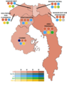
 Derry City and Strabane District Council Election 2023.svg 1,156 × 851; 635 KB
-
 Derry-strabane local election 2019.png 3,006 × 2,175; 186 KB
-
 European Parliament election, 1979-1999 (Northern Ireland, UK).svg 173 × 134; 50 KB
-
 European Parliament election, 2004-2014 (Northern Ireland, UK).svg 173 × 134; 50 KB
-
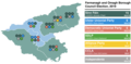
 Fermanagh and Omagh District Council Election 2023.svg 1,156 × 851; 1.42 MB
-
 Fermanagh and Omagh local election map 2019.png 3,130 × 1,528; 176 KB
-
 Fermanagh and Omagh2023.png 1,217 × 834; 148 KB
-
 Fermangh and Omagh - 2014 v2.png 1,217 × 834; 154 KB
-
 Fermangh and Omagh - 2014.png 1,989 × 1,528; 167 KB
-
 Fermangh and Omagh - 2019 v2.png 1,217 × 834; 153 KB
-
 Fermangh and Omagh - 2019 v3.png 1,217 × 834; 149 KB
-
 Fermangh and Omagh - 2019.png 1,989 × 1,528; 197 KB
-
 First preference votes Northern Ireland 2022.svg 573 × 729; 675 KB
-
 Lisburn and Castlereagh - 2014 V2.png 1,450 × 868; 140 KB
-
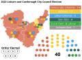 Lisburn and Castlereagh City Council Election 2023.svg 1,156 × 851; 699 KB
-
 Lisburn and Castlereagh Council - 2014.png 1,390 × 1,109; 179 KB
-
 Lisburn and Castlereagh Council - 2019 V2.png 1,450 × 868; 140 KB
-
 Lisburn and Castlereagh Council - 2019.png 1,450 × 868; 140 KB
-
 Lisburn and Castlereagh Council.png 1,390 × 1,109; 179 KB
-
 Lisburn-castlereagh-map-for-website.png 1,390 × 1,109; 171 KB
-
 Map of the 2017 Northern Ireland Assembly election.svg 2,199 × 1,505; 440 KB
-
 Map of the 2019 Derry and Strabane District Council election.svg 2,418 × 1,466; 498 KB
-
 Mid and East Antrim - 2014 v2.png 1,436 × 910; 131 KB
-
 Mid and East Antrim - 2014.png 1,096 × 913; 115 KB
-
 Mid and East Antrim - 2019 v2.png 1,436 × 910; 129 KB
-
 Mid and East Antrim - 2019 V2.png 1,436 × 910; 130 KB
-
 Mid and East Antrim - 2019 v3.png 1,436 × 910; 130 KB
-
 Mid and East Antrim - 2019.png 1,096 × 913; 114 KB
-
 Mid and East Antrim District Council Election 2023.svg 1,156 × 851; 756 KB
-
 Mid and East Antrim.png 1,096 × 913; 114 KB
-
 Mid Ulster - 2014.png 1,694 × 1,858; 299 KB
-
 Mid Ulster Council 2019.png 1,694 × 1,858; 299 KB
-
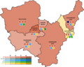
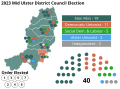 Mid Ulster District Council Election 2023.svg 1,156 × 851; 1.01 MB
-
 Newry, Mourne and Down - 2014 V2.png 1,216 × 822; 144 KB
-
 Newry, Mourne and Down - 2014.png 1,241 × 827; 142 KB
-
 Newry, Mourne and Down - 2019.png 1,216 × 822; 144 KB
-
 Newry, Mourne and Down District Council Election 2023.svg 1,156 × 851; 1.03 MB
-
 Newry, Mourne and Down.png 1,241 × 827; 142 KB
-
 Newry, Mourne and Down2023.png 1,216 × 822; 146 KB
-
 Northern Ireland Assembly election 1973.png 1,928 × 1,384; 167 KB
-
 Northern Ireland Assembly election 1982.png 1,928 × 956; 121 KB
-
 Northern Ireland Assembly election 1998.png 1,928 × 1,392; 166 KB
-
 Northern Ireland Assembly election 2003.png 1,928 × 956; 129 KB
-
 Northern Ireland Assembly Election 2007 - Results by Constituency.svg 1,395 × 731; 248 KB
-
 Northern Ireland Assembly election 2007.png 1,928 × 956; 129 KB
-
 Northern Ireland Assembly Election 2011 - Results by Constituency.svg 1,395 × 731; 220 KB
-
 Northern Ireland Assembly election 2011.png 1,928 × 956; 128 KB
-
 Northern Ireland Assembly Election 2016 - Results by Constituency.svg 1,395 × 731; 232 KB
-
 Northern Ireland Assembly election 2016.png 1,928 × 956; 98 KB
-
 Northern Ireland Assembly election results by constituency, 2017.png 770 × 470; 34 KB
-
 Northern Ireland assembly election seats 2011 de.svg 1,072 × 517; 159 KB
-
 Northern Ireland assembly election seats 2016 de.svg 1,188 × 502; 161 KB
-
 Northern Ireland assembly election seats 2016.svg 1,188 × 502; 171 KB
-
 Northern Ireland assembly election seats 2017 de.svg 1,188 × 502; 159 KB
-
 Northern Ireland assembly election seats 2017.svg 1,300 × 635; 176 KB
-
 Northern Ireland assembly election seats 2022 de.svg 1,188 × 502; 153 KB
-
 Northern Ireland Assembly election turnout 2017.svg 1,120 × 517; 287 KB
-

-

-
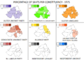 Northern Ireland Constitutional Convention 1975.png 1,928 × 1,384; 158 KB
-
 Northern Ireland Election Map 1998.svg 1,395 × 731; 263 KB
-
 Northern Ireland Election Map 2001.jpg 443 × 164; 24 KB
-
 Northern Ireland Election Map 2003.svg 1,395 × 731; 251 KB
-
 Northern Ireland election seats 1997-2005-by.png 1,116 × 241; 14 KB
-
 Northern Ireland election seats 1997-2005-by.svg 1,640 × 370; 63 KB
-
 Northern Ireland election seats 1997-2005.png 872 × 241; 12 KB
-
 Northern Ireland election seats 1997-2005.svg 1,290 × 330; 62 KB
-
 Northern Ireland election seats 1997-2010 de.svg 1,294 × 454; 285 KB
-
 Northern Ireland election seats 1997-2010.jpg 1,680 × 345; 235 KB
-
 Northern Ireland election seats 1997-2015 de.svg 1,184 × 308; 445 KB
-
 Northern Ireland election seats 1997-2015.svg 1,048 × 649; 63 KB
-
 Northern Ireland election seats 1997-2017.svg 1,400 × 710; 189 KB
-
 Northern Ireland election seats 1997-2019.svg 1,336 × 1,088; 208 KB
-
 Northern Ireland election seats 2007.png 1,170 × 665; 92 KB
-
 Northern Ireland Forum 1996.png 1,930 × 956; 118 KB
-
 Northern Ireland general election 1921.png 2,112 × 520; 66 KB
-
 Northern Ireland general election 1925.png 1,926 × 948; 112 KB
-
 Northern Ireland general election 1929.png 864 × 739; 53 KB
-
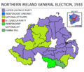 Northern Ireland general election 1933.png 864 × 739; 55 KB
-
 Northern Ireland general election 1938.png 864 × 739; 56 KB
-
 Northern Ireland general election 1945.png 864 × 739; 57 KB
-
 Northern Ireland general election 1949.png 864 × 739; 55 KB
-
 Northern Ireland general election 1953.png 864 × 739; 56 KB
-
 Northern Ireland general election 1958.png 864 × 739; 57 KB
-
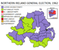 Northern Ireland general election 1962.png 864 × 739; 57 KB
-
 Northern Ireland general election 1965.png 864 × 739; 56 KB
-
 Northern Ireland general election 1969.png 864 × 739; 56 KB
-
 Northern Ireland local elections, 1924 (County Council Results).svg 322 × 273; 2.07 MB
-
 Northern Ireland local elections, 1973 (Council Control).svg 1,208 × 1,027; 195 KB
-
 Northern Ireland local elections, 1973 (Largest party).svg 1,208 × 1,027; 194 KB
-
 Northern Ireland local elections, 1977 (Council Control).svg 1,208 × 1,027; 195 KB
-
 Northern Ireland local elections, 1977 (Largest party).svg 1,208 × 1,027; 200 KB
-
 Northern Ireland local elections, 1981 (Council Control).svg 1,208 × 1,027; 194 KB
-
 Northern Ireland local elections, 1981 (Largest party).svg 1,208 × 1,027; 203 KB
-
 Northern Ireland local elections, 1985 (Council Control).svg 1,208 × 1,027; 194 KB
-
 Northern Ireland local elections, 1985 (Largest party).svg 1,208 × 1,027; 217 KB
-
 Northern Ireland local elections, 1993 (by ward).svg 639 × 515; 1.63 MB
-
 Northern Ireland local elections, 1997 (by ward).svg 639 × 515; 1.63 MB
-
 Northern Ireland local elections, 1997 (Council Control).svg 1,208 × 1,027; 194 KB
-
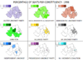
 Northern Ireland local elections, 2001 (by ward).svg 639 × 515; 1.63 MB
-
 Northern Ireland local elections, 2001 (Council Control).svg 1,208 × 1,027; 194 KB
-
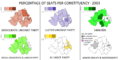
 Northern Ireland local elections, 2005 (Council Control).svg 1,208 × 1,027; 194 KB
-
 Northern Ireland local elections, 2011 (Council Control).svg 1,208 × 1,027; 194 KB
-
 Northern Ireland local elections, 2011.svg 1,208 × 1,027; 188 KB
-
 Northern Ireland local elections, 2014 (by council and DEA).svg 1,214 × 529; 1.96 MB
-
 Northern Ireland local elections, 2014 (by ward).svg 599 × 483; 1.21 MB
-
 Northern Ireland local elections, 2014.svg 1,208 × 1,027; 211 KB
-
 Northern Ireland local elections, 2019 (by council and DEA).svg 1,214 × 529; 1.9 MB
-
 Northern Ireland local elections, 2019.svg 1,208 × 1,027; 215 KB
-
 Northern Ireland local elections, 2023 (by council and DEA).svg 1,214 × 529; 1.9 MB
-
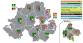
 Northern Ireland Parliamentary Constituencies 1929-1969.svg 2,000 × 1,500; 455 KB
-
 NorthernIrelandParliamentaryConstituency2005Results.svg 280 × 225; 87 KB
-
 NorthernIrelandParliamentaryConstituency2010Results.svg 779 × 635; 135 KB


.png)


.svg)
.svg)


.svg)
.svg)
.svg)
.svg)
.svg)
.svg)
.svg)
.svg)
.svg)
.svg)
.svg)
.svg)
.svg)
.svg)
.svg)
.svg)

.svg)
.svg)

.svg)

.svg)


