Category:Media from Atlas of Mutual Heritage - Koninklijke Bibliotheek
Jump to navigation
Jump to search
| NO WIKIDATA ID FOUND! Search for Media from Atlas of Mutual Heritage - Koninklijke Bibliotheek on Wikidata | |
| Upload media |
Media in category "Media from Atlas of Mutual Heritage - Koninklijke Bibliotheek"
The following 200 files are in this category, out of 904 total.
(previous page) (next page)-

-
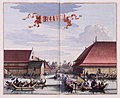
 AMH-4771-KB The Batavia fishmarket.jpg 2,400 × 2,058; 641 KB
-
 AMH-4802-KB The Dutch church or 'Kruiskerk' at Batavia.jpg 2,400 × 2,012; 613 KB
-
 AMH-4803-KB The city hall on Batavia.jpg 2,400 × 1,951; 644 KB
-
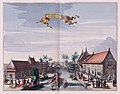
 AMH-4804-KB The spinning house at Batavia.jpg 2,400 × 1,995; 653 KB
-
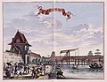
 AMH-4805-KB The slaughterhouse at Batavia.jpg 2,400 × 1,965; 560 KB
-
 AMH-4806-KB The orphanage at Batavia.jpg 2,400 × 2,034; 616 KB
-
 AMH-5632-KB Map of Asia.jpg 2,400 × 1,956; 888 KB
-
 AMH-5633-KB Map of the Turkish empire.jpg 2,400 × 1,911; 763 KB
-
 AMH-5634-KB Map of Arabia.jpg 2,400 × 1,935; 648 KB
-
 AMH-5635-KB Map of Persia.jpg 2,400 × 1,849; 744 KB
-
 AMH-5636-KB Map of the Mogul empire.jpg 2,400 × 1,962; 663 KB
-
 AMH-5637-KB The court of the great Mogul.jpg 2,400 × 1,946; 868 KB
-
 AMH-5638-KB Map of East India.jpg 2,400 × 1,996; 810 KB
-
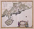
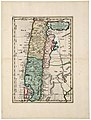
 AMH-5639-KB Map of southern India.jpg 2,400 × 1,932; 696 KB
-
 AMH-5640-KB Map of Ceylon.jpg 2,400 × 2,026; 692 KB
-
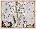
 AMH-5641-KB Map of Batavia and environs.jpg 2,400 × 1,941; 672 KB
-
 AMH-5642-KB View of the Nieuwe Poort at Batavia.jpg 2,400 × 1,856; 568 KB
-
 AMH-5643-KB View of the Tijgersgracht on Batavia.jpg 2,400 × 1,882; 536 KB
-
 AMH-5644-KB The conquest of Macassar by Speelman from 1666 to 1669.jpg 2,400 × 1,756; 713 KB
-
 AMH-5645-KB Map of China.jpg 2,400 × 1,875; 625 KB
-
 AMH-5646-KB Map of Fokien, China.jpg 2,400 × 2,005; 738 KB
-
 AMH-5647-KB Map of Hocsieu, China.jpg 2,400 × 1,020; 318 KB
-
 AMH-5648-KB Map of Guandong, China.jpg 2,400 × 1,990; 650 KB
-
 AMH-5649-KB Map depicting the journey by Joan Nieuhoff from Canton to Peking.jpg 2,400 × 2,024; 682 KB
-
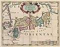
 AMH-5650-KB Map of Japan.jpg 2,400 × 1,803; 449 KB
-
 AMH-5651-KB Map of Japan.jpg 2,400 × 1,915; 822 KB
-
 AMH-5652-KB Map of the African continent.jpg 2,400 × 1,948; 795 KB
-
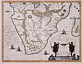 AMH-5653-KB Map of the southern part of the African continent.jpg 2,400 × 1,870; 606 KB
-
 AMH-5654-KB Map of South Africa and a view of Table Bay.jpg 2,400 × 1,928; 640 KB
-
 AMH-5655-KB Map of Madagascar.jpg 2,400 × 1,879; 543 KB
-
 AMH-6328-KB Map of a stretch of the West African coast.jpg 2,400 × 1,961; 761 KB
-
 AMH-6459-KB Map of Europe, Africa and Asia.jpg 2,400 × 1,712; 1,022 KB
-
 AMH-6460-KB Map of the African Gold and Slave coast.jpg 2,400 × 1,866; 852 KB
-
 AMH-6461-KB The vessels undertaking the first voyage led by De Houtman.jpg 2,400 × 1,824; 905 KB
-
 AMH-6462-KB The De Houtman expedition meets the residents of the Cape of Good Hope.jpg 2,400 × 1,900; 921 KB
-
 AMH-6463-KB Meeting with the village chief of Dampin, Sumatra, Sunda Straits.jpg 2,400 × 1,845; 931 KB
-

-
 AMH-6465-KB Dutch leave Bantam harbour.jpg 2,400 × 1,832; 933 KB
-
 AMH-6466-KB Map of Sumatra, Java, Borneo, Macassar, Madura, Bali.jpg 2,400 × 1,692; 948 KB
-
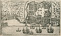
 AMH-6467-KB Bird's eye view of Bantam.jpg 2,400 × 1,464; 703 KB
-
 AMH-6468-KB East Indiamen in the Palabuan Strait.jpg 2,400 × 1,785; 826 KB
-
 AMH-6469-KB Map of the island of Amboina.jpg 2,400 × 1,656; 809 KB
-
 AMH-6470-KB Battle near Bantam between Wolfert Harmensz against the Portuguese.jpg 2,400 × 1,812; 790 KB
-
 AMH-6471-KB Battle near Malacca waged by Cornelis Matelief, 1606.jpg 2,400 × 1,816; 754 KB
-
 AMH-6472-KB Battle for Malacca between the VOC fleet and the Portuguese, 1606.jpg 2,400 × 1,795; 904 KB
-
 AMH-6473-KB Battle for Malacca between the VOC fleet and the Portuguese, 1606.jpg 2,400 × 1,804; 781 KB
-
 AMH-6474-KB View of Gamme Lamme on Ternate.jpg 2,400 × 1,696; 825 KB
-
 AMH-6576-KB Bird's eye view of bay and island, Mozambique.jpg 2,400 × 1,900; 1.25 MB
-
 AMH-6577-KB Bird's eye view of the city of Goa.jpg 2,400 × 1,681; 1.24 MB
-
 AMH-6598-KB View of the market in Goa.jpg 2,400 × 1,105; 609 KB
-
 AMH-6599-KB View of the island of St Helena.jpg 2,400 × 1,835; 1.05 MB
-
 AMH-6600-KB Different views of the island of St Helena.jpg 2,400 × 1,576; 1,004 KB
-
 AMH-6601-KB A number of views of the island of Ascencion.jpg 2,400 × 1,888; 1.16 MB
-
 AMH-6602-KB Bird's eye view of the city of Angra on Tercera, the Azores.jpg 2,400 × 1,451; 1,022 KB
-
 AMH-6603-KB Map of the West African coast.jpg 2,400 × 1,842; 1.13 MB
-
 AMH-6604-KB Map of South America.jpg 2,400 × 1,795; 1.2 MB
-
 AMH-6605-KB Map of the world in two globes.jpg 2,400 × 1,688; 942 KB
-
 AMH-6606-KB View of the city of Mocha.jpg 2,400 × 1,989; 1.16 MB
-
 AMH-6607-KB View of the city of Mascate.jpg 2,400 × 1,947; 1.2 MB
-
 AMH-6608-KB Map of the Arabian Peninsula.jpg 2,400 × 1,972; 1.31 MB
-
 AMH-6609-KB Bird's eye view of the roadstead at Bantam with De Houtman's fleet.jpg 2,400 × 1,787; 1.15 MB
-

-
-
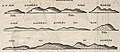
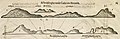 AMH-6629-KB View of the coast of Sumatra.jpg 2,400 × 780; 412 KB
-
 AMH-6630-KB Islands in the bay of Bantam.jpg 2,043 × 2,400; 1.01 MB
-
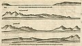
 AMH-6631-KB Views of the island of Lombok.jpg 2,400 × 978; 540 KB
-
 AMH-6632-KB Views of the island of Bali.jpg 2,400 × 1,180; 679 KB
-
 AMH-6633-KB Views of the island of Bali.jpg 2,400 × 1,365; 766 KB
-

-
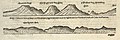
 AMH-6635-KB View of Cape Agulhas.jpg 2,400 × 428; 256 KB
-
 AMH-6636-KB Inhabitants of the Cape of Good Hope.jpg 2,400 × 1,581; 1.03 MB
-
 AMH-6637-KB Map of Madagascar with four inserts.jpg 2,400 × 1,642; 1,003 KB
-
 AMH-6638-KB View of the settlements of Spakenbourch and S. Angero on Madagascar.jpg 2,400 × 1,640; 1.24 MB
-
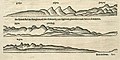
 AMH-6639-KB Views of the Sumatran coast and islands in the Sunda Straits.jpg 2,400 × 1,637; 773 KB
-
 AMH-6640-KB Views of the bay of Bantam.jpg 2,400 × 2,028; 1.11 MB
-
 AMH-6641-KB View of the islands off the coast of Sumatra.jpg 2,400 × 1,031; 524 KB
-
 AMH-6642-KB Bird's eye view of the Bay of Bantam.jpg 2,400 × 1,688; 1.16 MB
-
 AMH-6643-KB De Houtman's fleet at anchor near Bantam.jpg 2,400 × 1,445; 1.02 MB
-
 AMH-6644-KB The governor of Bantam grants an audience.jpg 2,400 × 1,634; 1.23 MB
-
 AMH-6645-KB View of Bantam market.jpg 2,400 × 886; 718 KB
-
 AMH-6646-KB Merchants of various origin in Bantam.jpg 2,400 × 1,646; 1.13 MB
-
 AMH-6647-KB Council of war in Bantam.jpg 2,400 × 1,609; 1.06 MB
-
 AMH-6648-KB A cock fight on Java.jpg 2,400 × 1,634; 1,021 KB
-
 AMH-6649-KB Javanese attack the vessel Amsterdam.jpg 2,400 × 1,634; 1.15 MB
-
 AMH-6650-KB View of the island of Lombok.jpg 2,400 × 1,028; 531 KB
-
 AMH-6651-KB View of the island of Lombok.jpg 2,400 × 898; 476 KB
-
 AMH-6652-KB Coastal view of the island of Bali.jpg 2,400 × 1,197; 633 KB
-
 AMH-6653-KB Views from the strait and bay of Balabuan on the eastern side of Java.jpg 2,400 × 1,562; 870 KB
-
-
 AMH-6655-KB View of Padang Bay on Bali.jpg 2,400 × 1,920; 1.05 MB
-
 AMH-6656-KB The king of Bali in a buffalo-drawn coach.jpg 2,400 × 1,829; 1.29 MB
-
 AMH-6657-KB Map of the island of Bali.jpg 2,400 × 1,637; 1.12 MB
-
 AMH-6658-KB Map of the island of St Helena.jpg 2,400 × 1,873; 1.28 MB
-
 AMH-6659-KB Map of Asia.jpg 2,400 × 1,665; 1.02 MB
-
 AMH-6660-KB Map of the Arabian peninsula.jpg 2,400 × 1,885; 1.21 MB
-
 AMH-6661-KB Map of Persia.jpg 2,400 × 1,905; 1.19 MB
-
 AMH-6662-KB Map of China.jpg 1,940 × 2,400; 1.06 MB
-
 AMH-6663-KB Map of the northern part of India and the Himalayas.jpg 2,400 × 1,893; 1.04 MB
-
 AMH-6664-KB Map of India.jpg 2,400 × 1,914; 1.08 MB
-
 AMH-6665-KB Two maps of Thailand, Malaysia and Sumatra.jpg 2,400 × 1,846; 1.05 MB
-
 AMH-6666-KB Map of Japan.jpg 2,400 × 1,872; 907 KB
-
 AMH-6667-KB Map of the Moluccas.jpg 2,400 × 1,914; 1,004 KB
-
 AMH-6668-KB Map of Java, Sumatra, Borneo and Malaysia.jpg 2,400 × 1,914; 1.01 MB
-
 AMH-6669-KB View of Batavia.jpg 2,400 × 1,789; 1,007 KB
-
 AMH-6671-KB Map of the Philippines and the Ladron islands.jpg 2,400 × 1,881; 881 KB
-
 AMH-6672-KB Map of Ceylon and the Maldives.jpg 2,400 × 1,851; 1.15 MB
-
 AMH-6673-KB Map of Africa and the Arabian peninsula.jpg 2,400 × 1,765; 1,016 KB
-
 AMH-6674-KB Map of West Africa.jpg 2,400 × 1,503; 1.03 MB
-
 AMH-6675-KB Map of the African Gold and Slave Coast.jpg 2,400 × 1,355; 761 KB
-
 AMH-6676-KB Map of the coast of Congo and Angola.jpg 2,400 × 1,905; 1.07 MB
-
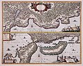
 AMH-6677-KB Two maps of the African east coast.jpg 2,400 × 1,511; 938 KB
-
 AMH-6678-KB Map of Madagascar.jpg 2,400 × 1,865; 1.04 MB
-
 AMH-6679-KB Map of North and Central America.jpg 2,400 × 1,729; 1,000 KB
-
 AMH-6680-KB Map of the Caribbean.jpg 2,400 × 1,645; 897 KB
-
 AMH-6681-KB Map of South America.jpg 2,400 × 1,744; 1,006 KB
-
 AMH-6682-KB Map of the northern part of South America.jpg 2,400 × 1,596; 1.02 MB
-
 AMH-6683-KB Map of the north east coast of South America.jpg 2,400 × 1,750; 975 KB
-
 AMH-6684-KB Map of Chile.jpg 1,818 × 2,400; 722 KB
-
 AMH-6685-KB Map of Vuurland with the Magelhaen Strait.jpg 2,400 × 1,800; 691 KB
-
 AMH-6686-KB Map of Brazil.jpg 2,400 × 1,809; 808 KB
-
 AMH-6687-KB View of Fort Victoria on Ambon.jpg 2,400 × 1,641; 1.06 MB
-
 AMH-6688-KB Map of the East African coast.jpg 2,400 × 1,703; 1.25 MB
-
 AMH-6689-KB View of Colombo.jpg 2,400 × 1,639; 1.21 MB
-
 AMH-6690-KB Map of the Horn of Africa, the Arab peninsula and India.jpg 2,400 × 1,667; 1.19 MB
-
 AMH-6691-KB Map of North and South America.jpg 2,400 × 1,892; 846 KB
-
 AMH-6692-KB Map of Nieuw-Nederland.jpg 2,400 × 2,003; 956 KB
-
 AMH-6696-KB Map of Guyana, or the Wild Coast.jpg 2,400 × 1,986; 962 KB
-
 AMH-6699-KB Map of All Saints Bay.jpg 2,400 × 1,895; 762 KB
-

-
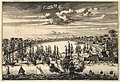
 AMH-6711-KB View of Puerto Rico.jpg 2,400 × 1,887; 978 KB
-
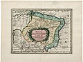
 AMH-6712-KB Map of the city and fort of Puerto Rico.jpg 2,400 × 1,881; 1.07 MB
-
 AMH-6713-KB Views of Olinda and Recife.jpg 2,400 × 1,904; 1.08 MB
-

-
 AMH-6715-KB Bird's eye view of the fort of Keulen near the Rio Grande and environs.jpg 2,400 × 1,908; 944 KB
-
 AMH-6716-KB Chart showing the Cape of St. Augustine.jpg 2,400 × 1,893; 999 KB
-
 AMH-6717-KB Chart showing the mouth of the Paraiba.jpg 2,400 × 1,890; 868 KB
-
 AMH-6718-KB Map of Curaçao.jpg 2,400 × 1,941; 894 KB
-
 AMH-6719-KB Bird's eye view of the seige of Fort Real in 1633 or 1635.jpg 2,400 × 1,897; 1.14 MB
-

-
 AMH-6721-KB Map of China and Korea.jpg 2,400 × 2,187; 1,001 KB
-
 AMH-6722-KB Map of North and South America.jpg 2,400 × 1,918; 1.04 MB
-
 AMH-6723-KB Map of the New Netherlands.jpg 2,400 × 1,933; 1.33 MB
-
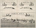
 AMH-6724-KB View of Puerto Rico.jpg 2,400 × 1,988; 1.05 MB
-
 AMH-6725-KB Map of the Caribbean region.jpg 2,400 × 1,916; 1.19 MB
-
 AMH-6726-KB The bay of Mauritius.jpg 2,400 × 2,067; 901 KB
-
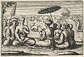
 AMH-6727-KB Dutch being entertained by the king of Ternate.jpg 2,400 × 2,059; 916 KB
-
 AMH-6728-KB Dutch vessels arriving in Achin.jpg 2,400 × 2,026; 832 KB
-
 AMH-6729-KB Arrival of Sebald de Weert in Matecalo.jpg 2,400 × 2,023; 810 KB
-
 AMH-6730-KB Sumatrans attacking shipwrecked sailors.jpg 2,400 × 2,026; 879 KB
-
 AMH-6731-KB Map of Asia.jpg 2,400 × 1,907; 1.04 MB
-
 AMH-6768-KB The bay of Mauritius.jpg 2,400 × 2,037; 808 KB
-
 AMH-6769-KB View of Goa.jpg 2,400 × 2,047; 797 KB
-
 AMH-6770-KB Dutch ships arrive in Achin.jpg 2,400 × 2,064; 806 KB
-
 AMH-6771-KB Arrival of Sebald de Weert in Matecalo.jpg 2,400 × 2,112; 818 KB
-
 AMH-6772-KB View of Malacca.jpg 2,400 × 2,046; 719 KB
-
 AMH-6773-KB View of Mozambique.jpg 2,400 × 2,067; 781 KB
-
 AMH-6774-KB Sumatrans attacking shipwrecked sailors.jpg 2,400 × 2,101; 822 KB
-
 AMH-6775-KB Siege of Batavia by the sultan of Mataram.jpg 2,400 × 2,008; 723 KB
-
 AMH-6776-KB Massacre after the shipwreck of the Batavia in 1629.jpg 2,400 × 2,130; 802 KB
-
 AMH-6815-KB Map of part of the Chinese coast.jpg 1,929 × 2,400; 1.14 MB
-
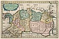
 AMH-6816-KB Map of Japan.jpg 2,400 × 1,627; 811 KB
-
 AMH-6818-KB View of Olinda.jpg 2,400 × 2,010; 1.16 MB
-
 AMH-6819-KB View of Isla Tamaraca.jpg 2,400 × 2,012; 1.09 MB
-
 AMH-6820-KB View of the mouth of the Paraiba River.jpg 2,400 × 2,008; 1.19 MB
-
 AMH-6821-KB View of Fort Ceulen on the Rio Grande.jpg 2,400 × 2,034; 1.16 MB
-
 AMH-6822-KB View of Porto Calvo.jpg 2,400 × 1,999; 1.34 MB
-
 AMH-6823-KB View of Serenhaim.jpg 2,400 × 1,991; 1.24 MB
-
 AMH-6824-KB View of Fort Maurits near Penedo.jpg 2,400 × 2,023; 1.21 MB
-
 AMH-6825-KB View of Siara.jpg 2,400 × 2,020; 1.15 MB
-
 AMH-6826-KB View of Mauritsstad.jpg 2,400 × 1,212; 562 KB
-
 AMH-6827-KB View of Fort Willem in Affogados.jpg 2,400 × 1,892; 1.31 MB
-
 AMH-6828-KB Map of Guiana.jpg 2,400 × 1,941; 1.02 MB
-
 AMH-6829-KB Map of Venezuela.jpg 2,400 × 1,963; 1.15 MB
-
 AMH-6830-KB Map of the coast of Chile.jpg 2,400 × 1,946; 1.03 MB
-
 AMH-6831-KB View of New Amsterdam.jpg 2,400 × 1,873; 1.1 MB
-
 AMH-6832-KB View of the city of Payte in Peru.jpg 2,400 × 1,855; 1.11 MB
-
 AMH-6833-KB Johan Maurits drives out the Portuguese.jpg 2,400 × 1,934; 1.25 MB
-
 AMH-6834-KB Battle between Dutch and Africans near El Mina in 1637.jpg 2,400 × 1,879; 1.23 MB
-
 AMH-6835-KB View of Ponta Tamandere.jpg 2,400 × 1,890; 1 MB
-
 AMH-6836-KB View of Fort Nassau, Ghana.jpg 2,400 × 1,983; 1.22 MB
-
 AMH-6837-KB View of Boavista.jpg 2,400 × 1,875; 952 KB
-
 AMH-6838-KB View of the northern part of India.jpg 2,400 × 2,001; 1.14 MB
-
 AMH-6839-KB The court of the great Mogul.jpg 2,400 × 1,943; 1.56 MB
-
 AMH-6840-KB View of Suratte.jpg 2,400 × 1,821; 1.16 MB
-
 AMH-6841-KB The twelve year old king of Deccan.jpg 2,400 × 1,897; 1.09 MB
-
 AMH-6842-KB View of Isfahan.jpg 2,400 × 1,993; 1.44 MB
-
 AMH-6843-KB Map of Persia.jpg 2,400 × 1,997; 1.22 MB
-
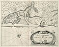
 AMH-6844-KB View of city and Fort Zeelandia on Taiwan.jpg 2,400 × 1,969; 1.01 MB
-
 AMH-6845-KB View of Hocsieu.jpg 2,400 × 1,005; 605 KB
-
 AMH-6846-KB The Dutch delegation led by Van Hoorn leaves Hocksieuw.jpg 2,400 × 1,980; 1.21 MB
-

-
 AMH-6848-KB The Dutch delegation presents gifts at the Imperial palace.jpg 2,400 × 1,995; 1.17 MB
-
 AMH-6849-KB The Dutch delegation led by Van Hoorn dines with a Chinese viceroy.jpg 2,400 × 2,024; 1.61 MB
-
-

-
 AMH-6852-KB The Dutch delegation led by Van Hoorn receives a letter from the Emperor.jpg 2,400 × 2,003; 1.25 MB
-
 AMH-6853-KB Map of the west coast of Africa.jpg 2,400 × 1,773; 1.06 MB
-
 AMH-6854-KB Map of Guinea.jpg 2,400 × 1,765; 987 KB
-
 AMH-6855-KB View of the fort of Tacaray.jpg 2,400 × 1,870; 1.13 MB


