Category:New York State Route 416
Jump to navigation
Jump to search
 | number: | (four hundred sixteen) |
|---|---|---|
| State highways in New York (state): | 396 · 397 · 398 · 400 · 402 · 403 · 404 · 406 · 408 · 409 · 410 · 411 · 412 · 414 · 415 · 416 · 417 · 418 · 419 · 420 · 421 · 423 · 424 · 425 · 426 · 427 · 428 · 429 · 430 · 431 · 433 · 434 · 436 |
State highway in Orange County, New York, US  | |||||
| Upload media | |||||
| Instance of | |||||
|---|---|---|---|---|---|
| Location | New York | ||||
| Transport network | |||||
| Owned by | |||||
| Maintained by | |||||
| Inception |
| ||||
| Length |
| ||||
| |||||
English: Media related to New York State Route 416.
Media in category "New York State Route 416"
The following 13 files are in this category, out of 13 total.
-
 Colored Cemetery (Montgomery, New York).jpg 585 × 965; 614 KB
-
 Flooded farmland after Tropical Storm Lee, Campbell Hall, NY.jpg 4,288 × 3,216; 5.73 MB
-
 Hamptonburgh, NY, Town Hall.jpg 1,604 × 956; 1.38 MB
-
 Harrison Meeting site.jpg 960 × 768; 827 KB
-
 Hill-Hold.jpg 847 × 637; 282 KB
-
 New York State Route 416 Map.svg 1,027 × 609; 2.46 MB
-
New York State Route 416.ogv 5 min 18 s, 320 × 240; 22.29 MB
-
 NY 416 flooded at Neelytown Road after Tropical Storm Lee, Montgomery, NY.jpg 3,788 × 2,732; 5.76 MB
-
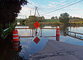
 NY 416 flooded by Wallkill River at I-84 following Hurricane Irene.jpg 4,288 × 3,216; 6.58 MB
-
 NY 416.jpg 2,576 × 1,932; 1.07 MB
-
 NY-416.svg 750 × 600; 5 KB
-
 Ottaway Community Newspapers headquarters.jpg 2,400 × 1,062; 679 KB
-
 USGS Montgomery map showing NY 84 and 416.gif 401 × 356; 75 KB
.jpg)


