Category:Old maps of Derry
Jump to navigation
Jump to search
Subcategories
This category has only the following subcategory.
Media in category "Old maps of Derry"
The following 9 files are in this category, out of 9 total.
-
-

-
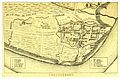
 CANE(1859) p122 MAP OF LONDONDERRY AS BESIEGED IN 1688.jpg 4,755 × 3,037; 3.79 MB
-
-
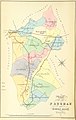
 CANE(1859) p054 MAP OF LONDONDERRY.jpg 2,315 × 1,515; 2.94 MB
-
 WALKER(1893) p197 MAP OF DERRY - AS BESIGED IN 1688-89.jpg 1,876 × 1,049; 859 KB
-
 Journal of the Royal Society of Antiquaries of Ireland (1915) (14757539126).jpg 4,256 × 2,348; 917 KB
-
-
 The plat of the Cittie of Londonderrie as it stands built and fortyfied (27114684854).jpg 5,368 × 4,324; 8.02 MB
_(By_Sir_T._A._L.)%27_(11014140793).jpg)
)%27_(11167446183).jpg)
_p122_MAP_OF_LONDONDERRY_AS_BESIEGED_IN_1688.jpg)
%27_(11041318385).jpg)
_p054_MAP_OF_LONDONDERRY.jpg)
_p197_MAP_OF_DERRY_-_AS_BESIGED_IN_1688-89.jpg)
_(14757539126).jpg)
_Company%27s_illustrated_guide_to_the_sporting_and_touring_grounds_of_the_north_of_Ireland_(1908)_(14593387888).jpg)
.jpg)