Category:Rapid transit maps
Jump to navigation
Jump to search
English: Maps of rapid transit lines and networks.
map or schematic diagram of fixed routes of bus, passenger rail and ferry networks | |||||
| Upload media | |||||
| Subclass of | |||||
|---|---|---|---|---|---|
| Depicts | public transport network | ||||
| |||||
See also:
- Category:Public transport maps for all kind of public transport maps
- Category:Metro maps for metro maps
- Category:Tram maps for tramway maps
- Category:Trolleybus maps for trolleybus maps
- Category:Bus maps for bus maps
- Category:Rail transport maps for railway maps
Subcategories
This category has the following 113 subcategories, out of 113 total.
!
- Public transport country maps (59 F)
*
A
B
C
- Public transport maps of Caracas (28 F)
D
- Public transport maps of Denver (14 F)
E
F
G
H
- Maps of Harbin Metro (11 F)
J
K
L
M
- Manchester Metrolink maps (61 F)
- MIO maps (2 F)
N
O
P
R
S
T
X
Z
Pages in category "Rapid transit maps"
This category contains only the following page.
Media in category "Rapid transit maps"
The following 77 files are in this category, out of 77 total.
-
 World Tramway Map.png 7,676 × 3,905; 2.52 MB
-
 Cagliari mappa SFM.svg 771 × 617; 3.63 MB
-
 Central Park depot map.svg 612 × 517; 96 KB
-
 Ciudades con metro LatAm.svg 793 × 963; 699 KB
-
 Ciudades con suburbano LatAm.svg 512 × 621; 353 KB
-
 Commuterline Merak MapJP.png 3,000 × 1,000; 348 KB
-
 Commuterline Tanjung Priok MapJP.png 3,000 × 1,000; 382 KB
-
 Express Occidentalis.png 1,080 × 2,145; 116 KB
-
 Karte Metro-, Tram- und Obussysteme.svg 1,736 × 2,326; 4.65 MB
-
 Karte ÖPNV-Netze Deutschland.svg 1,736 × 2,326; 4.64 MB
-
 OePNVSystemeDeutschland.png 1,172 × 1,700; 322 KB
-
 Global metro.png 2,729 × 1,482; 362 KB
-
 HangzhouMetroUnderConstruction.svg 3,985 × 2,247; 429 KB
-
 JabodebekLRTJP.png 2,560 × 2,560; 618 KB
-
 Karte der ÖPNV-Systeme in den Staaten der ehemaligen Sowjetunion.png 1,571 × 3,027; 1.44 MB
-
 Karte der ÖPNV-Systeme in den USA.png 2,204 × 1,353; 440 KB
-
 Karte der ÖPNV-Systeme in Deutschland 2008.png 1,535 × 2,257; 456 KB
-
 Karte der ÖPNV-Systeme in Lateinamerika.png 1,371 × 1,575; 356 KB
-
 Karte der ÖPNV-Systeme in Nordafrika.png 2,493 × 1,287; 239 KB
-
 Karte der ÖPNV-Systeme in Spanien und Portugal.png 3,303 × 2,617; 927 KB
-
 Karte ÖPNV-Systeme in der Türkei.png 3,656 × 1,750; 300 KB
-
 Karte ÖPNV-Systeme in Italien.png 2,260 × 1,551; 355 KB
-
 Kyiv Rapid Transit Map.svg 629 × 595; 593 KB
-
 LRT Bekasi MapJP.png 3,000 × 1,000; 518 KB
-
 LRT Cibubur MapJP.png 3,000 × 1,000; 512 KB
-
 Map of Cercania systems in Spain.png 1,645 × 1,369; 469 KB
-
 Mapa del Metro de la Ciudad de México.svg 3,091 × 3,247; 2.95 MB
-
 Mapa STC Metro Movilidad Integrada.svg 2,015 × 2,848; 9.36 MB
-
 Mappa Circumsalernitana inaugurazione servizio (1997).gif 1,024 × 721; 56 KB
-
 Mappa Circumsalernitana.png 1,024 × 721; 135 KB
-
 Mappa SFM Bologna.svg 1,044 × 901; 938 KB
-
 Maqueta Metro VLN.jpg 1,600 × 1,200; 379 KB
-
 MEGA Ahmedabad Metro Network Map August 2015.png 987 × 814; 72 KB
-
 MEGA Ahmedabad Metro Phase I Network Map.jpg 1,326 × 996; 142 KB
-
 Messina mappa Metroferrovia.svg 627 × 838; 2.55 MB
-
 Metro camisuandia nuevo.jpg 5,000 × 5,000; 2.64 MB
-
 Metro hispanorum.png 1,590 × 1,052; 134 KB
-
 Metro in the World.png 940 × 415; 111 KB
-
 Metro in the World.svg 940 × 415; 1.51 MB
-
 Metro Loco.svg 1,052 × 1,488; 1.45 MB
-
 Metro Museum in Shanghai.jpeg 4,032 × 3,024; 1.71 MB
-
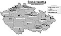 Metro, tram a trolejbusy v ČR.jpg 876 × 518; 148 KB
-
 Metromundi.png 2,384 × 1,312; 728 KB
-
 Miami Metro Map 2017.png 5,500 × 4,600; 835 KB
-
 MRTJ north South MapJP.png 3,000 × 1,000; 618 KB
-
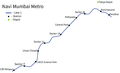 Navi Mumbai Metro Map.png 1,112 × 676; 36 KB
-
 Noapara depot map.svg 301 × 553; 55 KB
-
 NYC Subway Lines, not Services.png 3,000 × 3,800; 1,021 KB
-
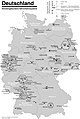 OePNVSystemeDeutschlandJanuar2003.jpg 1,260 × 1,877; 205 KB
-
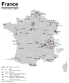 OePNVSystemeFrankreich-fr.png 1,204 × 1,445; 236 KB
-
 OePNVSystemeFrankreich.png 1,204 × 1,445; 165 KB
-
 OePNVSystemeJapanJanuar2003.png 1,503 × 2,223; 413 KB
-
 OePNVSystemePolenMai2007.png 1,500 × 1,836; 245 KB
-
 Palembang LRT MapJP.png 3,000 × 1,000; 430 KB
-
 Parma - mappa progetto metropolitana leggera 2005.svg 994 × 1,328; 6.59 MB
-
 Public transport system map of the USA.png 2,204 × 1,353; 440 KB
-
 Public transport systems of Italy.png 1,298 × 1,551; 251 KB
-
 Rail networks USA map.svg 959 × 593; 124 KB
-
 RFi-1612-DIC-2016-Higgs.jpg 3,154 × 3,508; 5.15 MB
-
 Salerno mappa servizio ferroviario metropolitano.svg 948 × 760; 2.44 MB
-
 Tees Valley Metro Route Map jpg.jpg 2,481 × 1,309; 282 KB
-
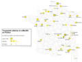 Transports urbains de France.png 1,072 × 811; 190 KB
-
 Tube map icon.svg 650 × 400; 18 KB
-
 Western European express.png 1,584 × 1,676; 95 KB
-
 World metro system cities.png 1,983 × 1,014; 279 KB
-
 World metro system city list.png 1,920 × 982; 287 KB
-
 World Metro systems November 2021.svg 940 × 415; 1.53 MB
-
 World Metro systems.png 940 × 415; 116 KB
-
 World Metro systems.svg 940 × 415; 1.53 MB
-
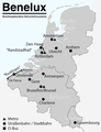 ÖPNV-System in den Benelux-Staaten.png 961 × 1,253; 146 KB
-
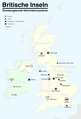 ÖPNV-Systeme auf den Britischen Inseln.png 1,845 × 2,715; 512 KB
-
 ÖPNV-Systeme in China.png 3,176 × 2,560; 1.25 MB
-
 ÖPNV-Systeme in Korea.png 1,638 × 2,644; 633 KB
-
 ÖPNV-Systeme in Südosteuropa.png 1,721 × 1,917; 444 KB
-
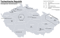 ÖPNV-Systeme Tschechische Republik.png 1,660 × 1,046; 207 KB
-
 ÖPNV-Südkorea de.svg 509 × 800; 182 KB
-
 Саратов 90 автобус.svg 484 × 540; 310 KB


.gif)


