Category:SVG labeled maps of administrative divisions of Greenland (location map scheme)
Jump to navigation
Jump to search


.svg)


_(Paris_zoom).svg)
.svg)
,_administrative_divisions_-_de_-_colored_(multizoom).svg)
_-_colored.svg)
.svg)
,_administrative_divisions_-_Nmbrs_(multizoom).svg)
,_administrative_divisions_-_de_-_colored.svg)
_-_de_-_colored.svg)

.svg)

.svg)
Media in category "SVG labeled maps of administrative divisions of Greenland (location map scheme)"
The following 5 files are in this category, out of 5 total.
-
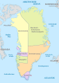 Greenland, administrative divisions - de - colored 2018.svg 1,181 × 1,669; 994 KB
-
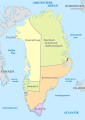 Greenland, administrative divisions - de - colored.svg 1,181 × 1,669; 997 KB
-
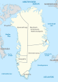 Greenland, administrative divisions - de.svg 1,181 × 1,669; 997 KB
-
 Greenland, administrative divisions - Nmbrs - colored.svg 1,181 × 1,669; 955 KB
-
 Greenland, administrative divisions - Nmbrs.svg 1,181 × 1,669; 941 KB


Categories:
- SVG labeled maps of administrative divisions of the Kingdom of Denmark (location map scheme)
- SVG labeled maps of administrative divisions of countries of Europe (location map scheme)
- SVG labeled maps of administrative divisions of countries of North America (location map scheme)
- SVG maps of Greenland
- Maps of municipalities in Greenland